


TN250-10 CTD and Nutrient Data
Summary
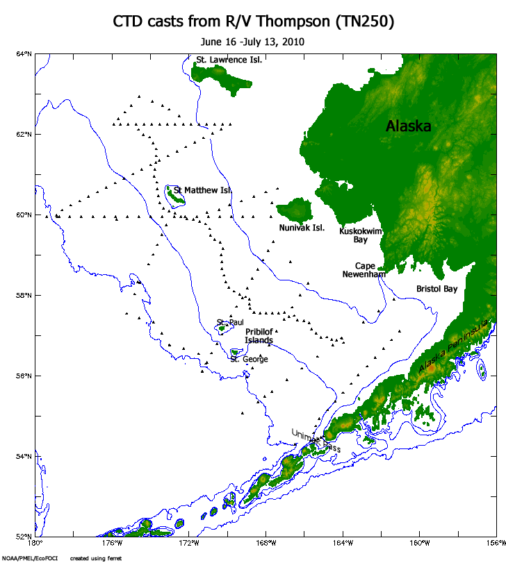
This Conductivity Temperature Depth (CTD) data set, consisting of 242 casts, was collected during a multi-disciplinary Bering Sea ice cruise on the R/V Thompson (TN250, June 16 - July 13, 2010). The cruise was funded by NSF for the Bering Sea Ecosystem Study-Bering Sea Integrated Ecosystem Research Program (BEST-BSIERP), and supported by numerous agencies and institutions. BEST-BSIERP together are the Bering Sea project. The CTD operations on this cruise were managed by personnel from NOAA/PMEL in the EcoFOCI program, with deployment assistance from Thompson personnel. Water samples from casts were collected by various parties relative to their research needs. Profile data from CTD instruments were processed at NOAA/PMEL/EcoFOCI using standard techniques. Data from bottle samples include phosphate, silicate, nitrate, nitrite, ammonium, and chlorophyll. Data files are an array on a 1-meter grid and combine both averaged CTD profile data, and bottle samples where depths with no data are listed as "-1E+10" in text data files, and as 1.0e-35 in NetCDF files.
Data are available in two formats: netCDF, and Ocean Data View ASCII files.
CTD data contacts: Phyllis Stabeno, Peggy Sullivan.
Nutrient and bottle data contact: Calvin Mordy.
Note: Data have been updated as of 02 Oct 2013.
Data access
- ORDER data for delivery by FTP
Additional information
| Identifier | |
| Versions |
|
| Subscribe | Subscribe to receive email when new or updated data is available. |
| Related projects | |
| Spatial Type | point |
| Language | English |
| Grant Code | 0732640 |
| ISO Topic Categories |
|
| Categories | |
| Platforms | |
| Instruments | |
| Events | |
| Sites | |
| GCMD Science Keywords |
|
| Documentation |
|
| Related links |
|
Temporal coverage
| Begin datetime | 2010-06-16 00:00:00 |
| End datetime | 2010-07-14 23:59:59 |
Spatial coverage
Map data from IBCSO, IBCAO, and Global Topography.
Maximum (North) Latitude:
63.00,
Minimum (South) Latitude:
54.00
Minimum (West) Longitude:
-180.00,
Maximum (East) Longitude:
-160.00
Primary point of contact information
Phyllis J. Stabeno <phyllis.stabeno@noaa.gov>
Additional contact information
- author: Phyllis J. Stabeno <phyllis.stabeno@noaa.gov>
- author: Rolf Sonnerup <rolf@u.washington.edu>
- author: Calvin W. Mordy <mordy@u.washington.edu>
- author: Terry E. Whitledge <terry@ims.uaf.edu>
- principalInvestigator: Calvin W. Mordy <mordy@u.washington.edu>
- originator: Peggy Sullivan <Peggy.Sullivan@noaa.gov>
- principalInvestigator: Phyllis J. Stabeno <phyllis.stabeno@noaa.gov>
- principalInvestigator: Rolf Sonnerup <rolf@u.washington.edu>
- principalInvestigator: Terry E. Whitledge <terry@ims.uaf.edu>
Citation
Stabeno, P., et al. 2011. TN250-10 CTD and Nutrient Data. Version 1.0. UCAR/NCAR - Earth Observing Laboratory. https://doi.org/10.5065/D6HQ3WXT. Accessed 20 Apr 2024.
Today's date is shown: please replace with the date of your most recent access.