Two images on the same day are available for the following dates: November 14, July 28, August 1. So the total number of blue squares is 192, while the total number of images is 195. The longest data gap is 16 days, from December 25 to January 10.
Brief Description and Further Information
The Canadian RADARSAT satellite collected 195 synthetic aperture radar (SAR) images of the SHEBA site between November 1, 1997, and October 8, 1998, or roughly one image every one to three days. The C-band (5.3 GHz) RADARSAT SAR imaged a swath on the earth 460 km wide (in ScanSAR mode) with a pixel size of 50 m, unhampered by clouds or darkness. The satellite data were received and processed into imagery at the Alaska SAR Facility (ASF) in Fairbanks. Sequential pairs of images were then processed by the RADARSAT Geophysical Processor System (RGPS) at the Jet Propulsion Laboratory (JPL) in Pasadena to derive the motion of the sea ice on a 5-km grid by tracking common features in each pair of images. Thus we have a year-long record of the spatial pattern of ice motion and the radar backscatter in the vicinity of the SHEBA site.
The preceding paragraph is taken from the introduction of a paper entitled "Sea Ice Kinematics and Surface Properties from RADARSAT SAR During the SHEBA Drift" by Harry Stern and Richard Moritz, published in the Journal of Geophysical Research (SHEBA special section, 2002). The paper describes the data sets in more detail and is available here as a pdf file:
Download PDF file (2 megabytes)
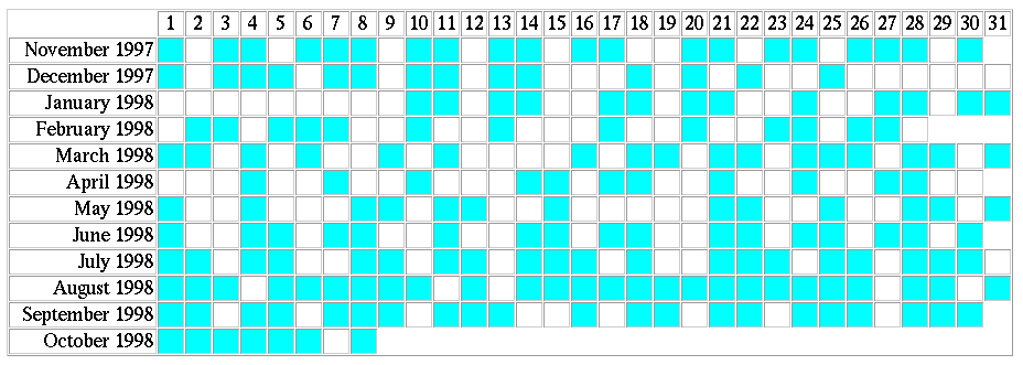
Date Chart
The following chart gives the dates on which SAR images are available.
The month is listed along the left side, and the day of the month is
listed along the top. A blue square means an image is available.
Two images on the same day are available for the following dates:
November 14, July 28, August 1. So the total number of blue squares
is 192, while the total number of images is 195.
The longest data gap is 16 days, from December 25 to January 10.
Summary of Data Products
Here is a summary of the data and derived products available through this web site (either directly or via links):
Administrative Details
Head to the dataset home page to obtain the images. You must not use the data for commercial purposes, and not distribute the data to other parties. You must put the copyright notice "Copyright CSA (year of reception)" on published images.
Acknowledgements for data products:
SAR imagery: Please acknowledge the Alaska Satellite Facility
and the SHEBA Project Office.
Ice motion: Please acknowledge the RADARSAT Geophysical
Processor System.
Ice deformation and other products: Please acknowledge the
SHEBA Project Office.
Questions? Contact Harry Stern by
E-mail:
harry@apl.washington.edu
Phone: 206-543-7253
Fax: 206-616-3142
U.S. Mail:
Polar Science Center / University of Washington
1013 NE 40th Street
Seattle, WA 98105-6698