Transitions 1999 and 2000 at Council, Alaska
A study of the spatial and temporal transitions of climate and ecosystems in the circumpolar Arctic
Introduction
The primary objectives for the field program at Council, Seward Peninsula, were to examine the characteristics and the mechanisms of feedback processes in land-atmosphere exchange.� These data on the surface energy and moisture exchange between atmosphere ecosystem, snow, permafrost and soil are being used to investigate the mechanisms for coupling the land surface to climate on seasonal and decadal time scales.� An ultimate aim is to produce realistic predictions of future outcomes of climate change in the Arctic.
Overall the project takes a comprehensive view of the study of the surface energy and moisture budgets as well as examining vegetation biogeochemical and biophysical characteristics in vegetation types representing a structural transition from tundra to forest.� Detailed data analysis, model development and spatial/temporal extrapolation are also key components of this project.� The research is entirely interdisciplinary and involves close interaction between ecosystems and physical climate system studies.
Council and the Seward Peninsula area
Council is located approximately 70 miles to the northeast of Nome on the Seward Peninsula.� The Peninsula itself encompasses a diversity of landscape and ecosystem types created by the various climatic and topographical settings.� The climate is somewhat continental with cool and windy summers along the coast but inland it is hotter and drier.� However, the area is considerably warmer and wetter than the North Slope or interior Alaska.� Hence, the Council area provided an excellent opportunity to investigate a wide variety of ecosystem types that may be important in future climate change.� It also allows us to examine what may happen under warmer and wetter conditions that may represent the future climate in interior Alaska.
Measurement program
Surface energy exchanges
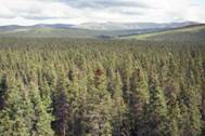
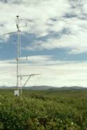
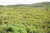
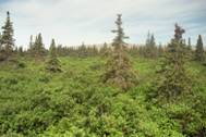
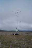
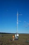
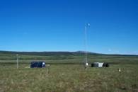
Measurements of surface energy and trace gas exchange were conducted over the vegetation types that may be considered to be important in future climate change.� These include tundra, low and high-density shrub tundra, treeline (woodland) and forest types.��� The sites represent a structural transition from tundra to forested vegetation and offer us an opportunity to examine the effects of physical vegetation properties on surface energy exchanges.� Sites were established in conjunction with the Walker group and are shown in Figure 1 and 2.
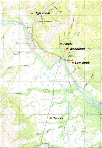
Figure 1.� Council site map including Tundra, Low shrub, High shrub, Woodland and Forest sites.� Heath and burned sites not shown.
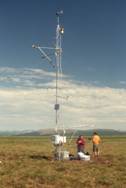
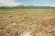
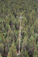
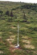
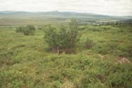
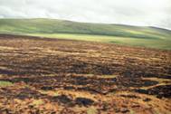
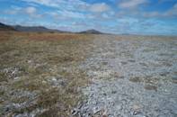
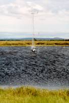
Measurements of energy and moisture exchange were made in conjunction with vegetation biomass and structure, soil thermal characteristics, permafrost characteristics and parameters important in catchment-scale hydrological processes.� Energy fluxes were measured at two permanent sites which represented the two end members of a vegetation transition between the typical Moist Acidic Tussock tundra (Tundra) and the white spruce forest site (Forest) (Figure 2a and b).� A third tower was a mobile tower that was used to characterize three other ecosystem types� including a low density shrub tundra (Low shrub), high density shrub tundra (High shrub), and a treeline analogue (Woodland) (Figure 2c,d and e).� In addition, we had the opportunity to measure over a recent Tundra burn (Figure 2f).� Other sites included a heath (Figure 2g), thaw lake (Figure 2h) and a similar second tussock tundra site (Figure 2h).
|
A
|
B
|
|
C
|
D
|
|
E
|
F
|
|
G
|
H
|
|
I
|
|
 �
�
 �
�
 �
�
 �
�
 �
�
 �
�
 �
�
 �
�
 �
�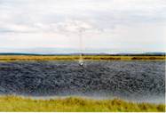
Figure 2. Sites established at Council A. Tundra B. Forest C. Low shrub D. High shrub E. Woodland F. Burned tundra. G. Heath H. Tundra2 I. Lake.
��������������������������������������������������������������������������������������������������
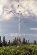
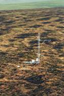
At each tower site an eddy covariance system was established to measure latent, sensible, and carbon dioxide fluxes.� A climate station also measured soil heat fluxes, soil moisture, soil temperature, net radiation, solar radiation balance, photosynthetic photon flux density, barometric pressure, air temperature at two or more levels, relative humidity at two or more levels and wind speed at two or more levels.� At the forested site profile measurements of temperature, water vapour and CO2 concentration were made to account for additional storage terms in the forest.� Forest biomass temperatures were made in order to quantify biomass heat storage.
In conjunction with the energy exchange and permafrost measurements, vegetation characteristics within the flux tower footprint were documented thoroughly.� Characteristics that were measured include; percentage abundance by species (with emphasis on moss characteristics), leaf area index, and canopy height.� Above ground biomass harvests were conducted during peak biomass at some sites to document net primary productivity (NPP), carbon and nitrogen content, and plant resource allocation by functional type.�
In addition, soil temperature profiles and soil moisture measurements at all sites were established during mid-summer to characterize permafrost dynamics over successive seasons.� These measurements will address how major arctic ecosystem types differ in their surface energy exchange and permafrost dynamics and how this will likely affect the physical soil environment (i.e. thermokarst development) and climate feedbacks on different time scales.
Preliminary results quantifying the effect of different vegetation types on the partitioning of energy within an ecosystem confirm some of the previous work from the ARCSS Flux Study and measurements from Ivotuk.� It is suggested that one of the primary controls on surface energy exchanges is the development of a leafed canopy.� A low shrub density seems sufficient to alter energy partitioning and further canopy development including the establishment of larger spruce trees has a lesser effect than the original canopy addition.� The results suggest that climatically sensitive transitions between vegetation types (e.g. tundra to shrub) could be very important in future feedbacks to climate change. The field data has also allowed a more detailed examination of some of the vegetation � land � atmosphere processes that may control these feedback mechanisms.
Boundary layer studies
An integrated sounding system (NCAR) and tethered balloon system (Monash University) were used to characterize boundary layer profiles simultaneously over both tundra and spruce ecosystem types in order to better understand potential influences of vegetation on larger scales (Figure 3).� Two systems were operated between in 2000 and one system in 1999.�� Data from the Radio Acoustic Sounding System and the upper air soundings will be used to develop better water vapour transport parameterization in the regional climate model (ArcSYM) and to investigate the influence of surface fluxes of heat and moisture in boundary layer development in the Arctic. We will also attempt to calculate regional fluxes utilizing these boundary layer measurements.
Preliminary measurements of heating over the tundra and forest confirm larger heating rates over the forest however the magnitudes of these contrasts are unlikely to influence synoptic scale features such as the arctic front.
|
A��
|
B
|
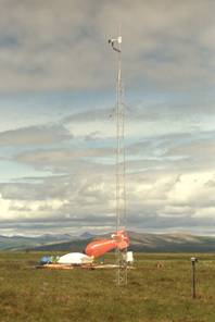
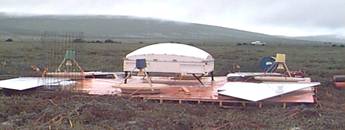
Figure 3. A. Thethersonde and Integrated Sounding system on the Tundra.� B.� Assembly and testing of the Radio Acoustic Sounding system and Doppler wind profiler at the tundra.
Chamber based measurements
A static chamber system encompassing a Licor-6262 was used to estimate fluxes of CO2 (light and dark measurements) and water vapour from 30 collars in the Tundra site in 1999 and 2000.� An intensive period of chamber measurements encompassed a mix of plant functional types in order to determine the contribution of different functional types, especially mosses, to the overall grid-scale fluxes.� A linear mixing model will be applied to chamber data to partition the contributions from different functional types.� In addition the controls on moss photosynthesis and evaporation were examined and chamber and eddy covariance methods will be validated (Figure 4).
|
A
|
B
|
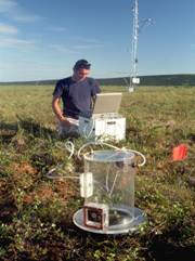
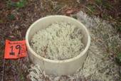
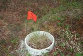
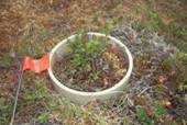
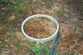
Figure 4. A. Chamber measurements being made at the tundra site. B. Chamber collars at the tundra site showing mixes of functional types being measured.
Additional Moss measurements
In addition to chamber based measurements of fluxes, collars containing homogeneous moss types were instrumented with soil suction and soil water content probes to examine how water moves through the moss and organic layers and to look at how this effects water loss under varying meteorological conditions.� In addition, the thermal conductivity of the mosses was measured over varying soil water contents in order to better quantify moss physical parameters.� In conjunction with Mack, litter decomposition was measured at both the tundra and spruce sites.� Litter and buried bags were used to examine the relative importance of litter quality and substrate microclimate as controls on decomposition and net mineralization.
Hydrology
We are working in conjunction with Hinzman to improve the understanding of the role that soil moisture and surface temperature play in affecting the surface energy balance, sub-surface thermal dynamics and vegetation distribution.� Soil moisture storage in the active layer is a key variable needed to improve understanding of most ecological process interactions and atmospheric/terrestrial linkages in arctic regions.� As such, we are collaborating in our field measurement program and modeling efforts to understand the interdependent controls on and responses to soil moisture.�
Permafrost dynamics measurements
Temperature and Moisture Dynamics in the Active Layer at Four Ivotuk Sites
Continuous measurements of the air, ground surface and soil temperature (at ten different depths in the active layer and near-surface permafrost) and the soil moisture at three to four different depths in the active layer were made at the four Council sites by Romanovsky.� Each site was established at the locations of the flux measurement towers. At each site, the air temperature, ground (including ground surface and 10 to 11 depths down to 80 to 104 cm) temperatures and ground moisture at three depths will be recorded hourly during the entire year.
The ground temperatures were surprisingly warm. The warmest soil temperatures were at the �Shrub� site, where temperature at 1 m depth was� +2.7�C on August 1. It seems there is no near-surface permafrost at this site. Also, very likely there is no near-surface permafrost at the �Forest� site, where temperature at 1 m depth was� +2.1�C on August 1.
At the �Woodland� site, there was a frozen layer between 55 and 70 cm (the deepest thermistor). We need complete our entire year of measurements to answer the question if it is permafrost or just relic of the seasonally frozen layer. Temperature at 70 cm was -0.1�C on August 1.
Permafrost definitely exits at the �Tundra� site, where the active layer thickness was only 35 cm on August 1. However, the upper-permafrost temperatures were very high. At 1.06 m, the soil temperature was -0.15�C on August 1. Also, we could observe many early stage thermokarst features at this site. We installed several single-probe temperature loggers in these thermocarst depressions at the depths between 0.5 and 1.1 meter. This temperature data will show if the active layer within these thermokarst depressions will freeze completely during the winter, or if some talik (unfrozen layer between the active layer bottom and the permafrost table) already exist in there.
Modeling vegetation dynamics
Our research on vegetation dynamics is focused at both the stand-scale and the landscape scale.� At the stand-scale our research is focused on the development of a dynamic vegetation model (DVM), which will model the structure and function of arctic vegetation using the plant-functional type (PFT) concept; PFTs are groupings of species with similar growth forms and functional traits.� This research represents the Ph.D. dissertation of Catharine Copass, a graduate student at the University of Alaska Fairbanks.� Programming work during the last year has focused on modifying the Terrestrial Ecosystem Model (TEM) to simulate the biogeochemical dynamics of individual PFTs of a stand.� We are currently analyzing field data from the first two years to determine parameters for the model and then to evaluate its performance in simulating monthly carbon and nitrogen dynamics of PFTs for the different stands examined in 1998 and 1999.
Our field work in 1999 was conducted from June 7 though August 28 in Council on the Seward Peninsula.� The vegetation types in this area form a hypothetical toposequence from tundra to treeline vegetation, which complements our field work in 1998, which focused on potential transitions among different tundra vegetation types.� We investigated how different combinations of PFTs influenced carbon and nitrogen dynamics. Biophysical (height, percent cover) and biogeochemical (biomass carbon and nitrogen content) measurements were made in tundra, low shrub tundra and woodland vegetation types.� Similar measurements will be made in the high shrub and forest sites in the 2000 field season.� The results of this field work are being used to elucidate competitive interactions among PFTs for water, nutrients, and light that need to be incorporated into the in the DVM.�
Our research on vegetation dynamics at the landscape scale focuses on using the satellite record to evaluate changes in land-cover that have occurred in the Council area of the Seward Peninsula.� This research represents the M.S. thesis project of Cherie Silapaswan, a graduate student at the University of Alaska Fairbanks.� In this analysis we expect to be able to identify both the rate and extent of treeline change and the effect of fire on vegetation dynamics in both tundra and forested ecosystems.� Our landscape-scale research effort focuses on using change vector analysis (CVA) to analyze vegetation transitions across five Landsat multi-spectral scanner (MSS), thematic mapper (TM), and enhanced thematic mapper (ETM+) scenes: 1999 (ETM+); 1992 (TM); 1986; (TM), 1977 (MSS), and 1975 (MSS).� The CVA algorithm produces two �channels� of output change information: 1) change vector direction; and 2) multispectral change magnitude. Essentially, CVA magnitude is computed as an Euclidean distance and, direction is computed as an angle of change; the distance represents the amount of change, and the direction represents the type of land-cover change.� Our efforts over the last year have largely focused on the two tasks required prior to conducting the CVA: (1) geographic rectification of the imagery, and (2) radiometric correction of the imagery for atmospheric scatter, clouds, and sensor calibration drift.� During the 1999 field season we traveled to the Council area in July to collect GPS data on ground control points for geographic rectification of the imagery. All the scenes mentioned above have been both geographically rectified and radiometrically corrected.� Currently we have also conducted a CVA, and are currently in the process of reviewing the results of the analysis.�
Modeling permafrost dynamics
Soil temperature dynamics play an important role in the carbon dynamics of arctic tundra ecosystems.� In a previous study, we successfully modeled the interactions between permafrost and carbon dynamics of black spruce ecosystems in North America by coupling a soil thermal model to the Terrestrial Ecosystem Model (TEM).� A manuscript has been prepared on this research (Zhuang, Romanovsky, and McGuire, in preparation), and we are in the process revising the manuscript for submission.� To explore the possibility of implementing this version of TEM to simulate the monthly soil temperature dynamics of tundra ecosystems, we parameterized the model for the soil properties of a tussock tundra ecosystem at the Toolik Lake LTER site, where soil temperatures were measured at depths of 10, 20, and 35 cm (1996 and 1997) or 40 cm (1995).� To initialize our simulation from 1974 through 1994, we used air temperature and precipitation observed at the Bettles FAA Airport.� From 1995 through 1997, we drove our simulation with air temperature data observed at Toolik Lake and precipitation measured at Bettles.� The regressions between observed and simulated data indicate that the model explains a substantial amount of the observed variability (R2 = 0.96 at 10 cm, 0.82 at 20 cm, 0.74 at 35 cm, and 0.82 at 40 cm).� The slopes of the regressions indicate that the model tends to slightly underestimate soil temperature at depth (slopes = 0.94 at 10 cm, 0.79 at 20 cm, 0.78 at 35 cm, and 0.79 at 40 cm); intercepts of the regressions did not differ from 0.� These results indicate that the model may be useful for modeling the interaction between permafrost and carbon dynamics of tundra ecosystems at large spatial scales.� Application of the model to large spatial scales requires parameterizing the model for additional tundra vegetation types.� Our intention is to incorporate the permafrost dynamics into the dynamic vegetation model that is under development and parameterize the soil thermal dynamics for each of the stands that have been studied at Ivotuk and Council.� A poster presentation on the above research will be presented by Qianlai Zhuang at the 2000 LAII Science Meeting.
Modeling biogeochemical cycles
Our goals in modeling biogeochemistry are focused on the stand scale, the landscape scale, and the pan-arctic scale.� Our primary goal with in the stand-scale research in year two was to make progress on the dynamic vegetation model and verify the dynamics of coupled biogeochemistry-permafrost in the Terrestrial Ecosystem Model (TEM) for different vegetation types.� As mentioned earlier, programming work on the dynamic vegetation model during the last year has focused on modifying the TEM to simulate the biogeochemical dynamics of individual PFTs of a stand.� We are currently analyzing field data from the first two years to determine parameters for the model and then to evaluate its performance in simulating monthly carbon and nitrogen dynamics of PFTs for the different stands examined in 1998 and 1999.� With respect to the coupled biogeochemistry-permafrost dynamics of TEM, we have successfully parameterized the model and verified its performance for both forest and tundra vegetation types.�
Our research efforts at the landscape scale focus on the response of historical carbon dynamics for Alaska to historical changes in CO2, climate, and fire disturbance, including fire disturbance of tundra ecosystems. To evaluate how historical C storage in Alaska may have been influenced by fire disturbance, climate variation, and rising atmospheric CO2 between 1950 and 1995, we conducted three simulations with the Terrestrial Ecosystem Model (TEM) that included responses of C storage to: CO2 only, CO2 and climate, and CO2, climate, and fire disturbance.� Between 1950 and 1995, the simulations of TEM indicate that C storage in Alaska increased between 2.0 and 2.9 1012 g� (Tg) C yr-1 depending on assumptions of fire severity.� The partitioning of effects indicate that rising CO2 was responsible for an increase in C storage of 3.6 Tg C yr-1 and that climatic variation was responsible for a loss of 0.3 Tg C yr-1.� The simulations indicate that fire disturbance, which includes changes in C storage associated with both fire emissions and subsequent succession, was responsible for the loss of 0.4 to 1.3 Tg C yr-1 depending on assumptions for fire severity. In contrast to the overall period, historical fire disturbance accounts for increases in C storage of between 3.1 and 10.0 Tg C yr-1 during the 1980s for the lowest and highest assumptions of severity, respectively.� This result suggests that regrowth associated with past fire disturbance was greater than losses associated with fire emissions during the 1980s, and that the strength of the regrowth effect increases with fire severity.� Our analysis suggests that fire disturbance, rising CO2 and climate variation all play substantial roles in the C dynamics of tundra and boreal forest in Alaska, and that modeling contemporary C dynamics for high latitude ecosystems requires a temporally and spatially explicit approach that incorporates the historical effects of fire disturbance.� A poster presentation by A. David McGuire will describe this research at the 2000 LAII Science Meeting.
At the pan-arctic scale, we are comparing the results of inverse and forward modeling simulations of historical carbon dynamics in high latitudes.� A comparison between one inversion model and four terrestrial biosphere models suggests good agreement with respect to high latitude carbon exchange.�
Modeling climate dynamics
����������� The ultimate goal in the modeling effort of our project is to couple models of regional climate, land-surface processes, permafrost dynamics, and ecosystem dynamics to conduct pan-Arctic simulations for assessing projected responses and feedbacks of arctic ecosystems in the context of the earth system.� The models to be coupled include Lynch's Arctic Region Climate System Model (ARCSyM), Bonan's Land Surface Model (LSM) of the National Center for Atmospheric Research, Romanovsky's permafrost model based on the modified Goodrich approach, and McGuire's Terrestrial Ecosystem Model (TEM).� Our strategy in this project is to make progress in modifying the stand-alone models early in the project and to couple the models later in the project.�
With respect to LSM modifications, progress has been made with respect to several issues.� Chapin has continued to work with Lynch and Bonan to modify the vegetation of LSM based on a 1-km vegetation map of Alaska classified from spectral analyses of the Advanced Very High Resolution Radiometer (AVHRR).� The vegetation types within 40-km grids for Alaska were aggregated for Alaska and regional climate simulations were conducted for the Alaska domain in the Arctic.� The results of these simulations are described in Lynch's report.
Beringer, Lynch and Bonan have modified the NCAR Land Surface Model (LSM) to add additional soil texture types including mosses and lichens to more realistically represent northern soils.� The addition of a surface layer of moss underlain by peat and loam had a substantial impact on land-atmosphere processes.� Mosses acted as an insulative layer producing cooler summer temperatures (6.9oC lower at 0.5m) and warmer winter temperatures (2.3oC higher at 0.5m) compared to a homogenous loam soil column.� The moss soil column had a greater surface infiltration that lead to greater storage of soil moisture in lower layers compared with a homogeneous loam column.� The added ability to prescribe different soil textures for different soil depths resulted in a different and more realistic distribution of soil water within the column.� Mosses modulated the surface energy exchanges by decreasing soil heat flux (43% in July) and increasing turbulent fluxes of heat (100% in July) and water (15% in July).� Mosses were also found to be more effective contributors to total latent heating than a bare loam surface.� The next step is to determine whether these more realistic representations of arctic systems produce a strong enough effect to influence regional climate.� Further studies are planned with the University of Boulder Colorado to address this issue.� In addition, the current ARCSyM model uses a single loam soil type for all of Alaska and Ping and Lynch are working with us to produce a realistic spatial soils dataset for future regional climate simulations.
Lynch, McIlwaine, Beringer and Bonan have examined the sensitivity of LSM to climatic change� using a multivariate reduced form model.� Here the strongest sensitivities arose from temperature, incoming shortwave and downwelling longwave energy, but significant non-linearities and interactions also arose (Lynch at al. Submitted).� In a similar approach Beringer, McIlwaine, Lynch and Bonan examined the sensitivity of LSM to surface parameters including leaf area index, roughness length, and albedo.� These studies will help identify parameters that require additional attention in the field component of the project.
REU� Program
REU and other funding provided the opportunity for students to join the research team at Council.� Many students, including one local high school student, participated in the collection of field data, led journal discussions, and interacted with visiting PI�s.� In addition, the students were responsible for the design and implementation of their own research project. �Shana Pennington compared of water and photosynthetic flux from different lichen types. Sarah Roberts worked extensively with the NCAR team, and used her experience to make a comparison of atmospheric latent heating above tundra and open spruce forest. Ian McHugh collected initial data for an honor�s project investigation of water vapour transport and vertical mixing above tundra and spruce ecosystems.� Kate Hoffman examined a recent tundra burn and the impacts of fire on vegetation and surface energy exchange.� Henry Titus, a high school student from White Mountain, Alaska evaluated microscale variability in soil surface temperatures in a white spruce forest.� We appreciate the dedication of these students; it is due to their hard work that we were able to achieve so much.�
|
Ducky |
Kate Hoffman |
Henry Titus |
|
Shana Pennington |
Sarah Roberts |
Chase Grey |
|
Johannes Dietz |
Ian McHugh |
Chris Wendt |
|
|
|
|


Interaction with other projects and outreach
����������� We have made a major effort to interact with other ATLAS and SIMS projects in both field research and synthesis.� Our closest interactions have been with the University of Colorado component our ATLAS project, which are described above.� In brief, we have used our field measurements to reparameterize the Land Surface Model (LSM) to include mosses and organic soils and performed sensitivity analyses that show that this substantially improves the realism with which the model simulates land-atmosphere interactions (Beringer et al., in preparation).� The NCAR boundary layer measurements and profile measurements (made by Nigel Tapper of Monash University in conjunction with Beringer and Chapin) provide the first linkage of surface fluxes with atmospheric consequences.� Thus we have now linked the ecological and the climatological components closely with both modeling and field efforts.� This has been accomplished through active collaboration of our group in the atmospheric modeling efforts and participation of members of the Univ. of Colorado group in the fieldwork component.
����������� In 1999, we selected our sites for flux measurements in Council jointly with the Walker project and jointly decided what measurements should be made and how we would link the results to Walker�s vegetation mapping.� The collaborative research on these sites continues in the coming field season.� Walker�s work is important in providing a large-scale context for the dynamic vegetation model that we are developing.� Ping sampled soils on our soils, to provide parameters that will be used in extrapolating the land surface model and the carbon balance model to all of Alaskan tundra.� We have also worked closely with Hinzman in selecting sites near Council where we can combine our measurements of hydrologic parameters (precipitation and evapotranspiration with his measurements of stream runoff.� Between the two projects, we have instrumented the four major vegetation types in the Melsing Creek watershed where Hinzman is measuring runoff.� These sites will be used for snow studies in spring 2000 in collaboration with Sturm, Beringer, Chapin and Hinzman. Simultaneous measurements will be made on a climatic gradient from Prudhoe Bay to Ivotuk and Council where energy exchange and snow melt studies will be conducted.
����������� In terms of synthesis, we have actively collaborated with virtually all LAII and SIMS groups working in the Arctic (see publication list).� Particularly notable is the completion of a high-latitude synthesis of climate feedbacks, which is now in review in Global Change Biology.� This integrates the research findings of the two Alaskan LTERs, the BOREAS project in Canada and the LAII (FLUX and ATLAS) studies in Alaska.� Other ATLAS/SIMS investigators involved in this synthesis include Oechel, Vourlitis, Williams, and Rastetter.
The proximity of the ATLAS field sites to both the town of Council and other communities of the Seward Peninsula have allowed us to expand on the outreach work that begun in 1998 by the Lloyd and Fastie group.� We have been establishing contacts in the Nome area schools and the community seems very interested and supportive of the ATLAS program. Henry Titus, a high school student from White Mountain worked on the project for the summer and took responsibility for documenting the vegetation composition of the forest site.� In his words, it was �the best summer I ever had�.� We plan to continue working with him in the coming field season.�
Acknowledgements
The investigators would like to acknowledge the assistance of the National Science Foundation Arctic System Science Program for their support.� In addition the efforts of the Polar Ice Coring Office in making the field campaign at Council a success is greatly appreciated. We would also like to thank the community for their support and local advice over the summer.� Finally, we would like to thank the undergraduate students that made it possible to achieve as much as we did this summer.