(DRAFT) JAM 9/5/97
SHEBA Data Management Plan
UCAR Joint Office for Science Support
1. Introduction and Background
The Surface Heat Budget of the Arctic Ocean (SHEBA) Project is designed as a multi-agency sponsored, inter-disciplinary project with many investigators and varied instrumentation. An integrated data management activity is central to providing a complete database that is easily accessible to all project investigators and the science community in general. The SHEBA Project Office will be responsible for developing and implementing an integrated data management strategy and coordination amongst data centers. The UCAR Joint Office for Science Support (JOSS) has been funded by the National Science Foundation to work with the SHEBA Project Office (SPO) in the development and implementation of data management plan to support Phase II SHEBA activities.
The SHEBA Project is a multi-agency inter-disciplinary effort to address the interaction of the surface energy balance, atmospheric radiation and clouds of the Arctic Ocean. SHEBA is part of the larger Arctic System Science / Ocean-Atmosphere-Ice Interactions (ARCSS/OAII) Program sponsored by the National Science Foundation. The primary goal of SHEBA is to characterize the surface radiation balance, mass changes of the sea ice, the storage and retrieval of energy and salt in the ocean mixed layer, the formation of clouds and their interplay with the radiation balance, and the relationships between the air-sea-ice system and the signals received by satellite-borne remote sensors. The data collected and supporting information will all be applied to improving how the polar processes are represented in climate models. Further details of objectives, rationale and approach are provided in the SHEBA Prospectus 1995, SHEBA Science Plan, July 1996, and SHEBA Implementation Plan, June 1997 available from the SPO (http://sheba.apl.washington.edu)
The SHEBA field program will consist of a multi-season deployment of an ice station in the Arctic Ocean (initial point approximately 143W- 76N) north of Prudhoe Bay, Alaska. The Canadian Coast Guard Ship CCGS Des Groseilliers will act as the central base of operations on the Arctic ice pack. Deployment is planned for approximately 13 months from mid-September, 1997 through freeze-up (approximately mid-October), 1998. Logistics support will be provided by the SHEBA Logistics Office. It is anticipated that routine visits to the ice station by aircraft will be made approximately once per 6 weeks. During the field experiment, the ice will probably drift in a generally southward and westward direction. Measurements at local and aggregate scales will be made over a region of 10-100 km diameter, centered on the high resolution measurement program at the ice station. Several intensive Observing Periods (IOP's) will occur during the experiment, making use of aircraft, submarines, satellites and autonomous platforms.
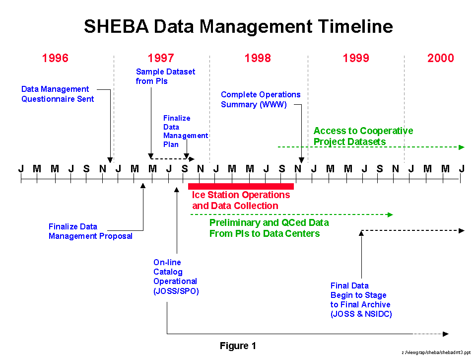
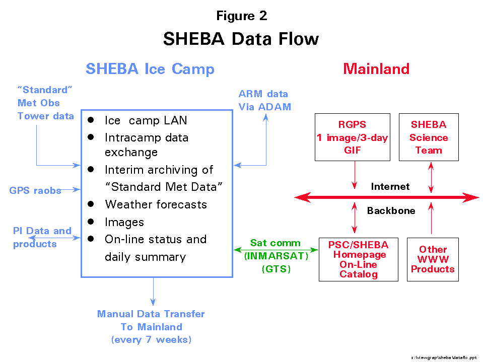
JOSS has primary responsibility for the implementation of the data management approach described in this plan. The final objective is a high quality data archive that has easy and timely access by a large community of investigators. This is a large task given the diversity of participation and instrumentation planned for SHEBA. In addition, several other National Data Centers will assist in this project in assuring the availability of this rich dataset. Figure 1 provides a schematic overview of the chronology of SHEBA data management activities during phase II. It is intended to highlight the important tasks and requirements that are part of the broadest concept of SHEBA data management support. Figure 2 shows the principal features of the SHEBA data flow during the upcoming field program.
UCAR/ JOSS will collaborate with the SPO and together they have determined that the following tasks absolutely essential to providing an acceptable level of data management support for SHEBA. Details of work required under each task are discussed in subsequent sections.
1. Provision of an on-line catalog at the ice station and on the mainland utilizing the JOSS data management system to provide primary access to summary data and documentation of activities during and following the field season.
2. Access to preliminary datasets and selected operational data using the on-line catalog and CODIAC during and after the 13 month field deployment.
3. Suggest standardized format(s) and guidelines for dataset documentation, status and summary reporting and other important data management procedures as necessary to assure complete documentation of project activities.
4. Assist SPO with planning and coordination of data management activities among other agencies, projects and groups to meet investigator needs at the ice station and on the mainland.
5. Coordinate the transfer of SHEBA datasets to the final archive at the National Snow and Ice Data Center (NSIDC).
These tasks are complementary with the role of the SPO in supporting SHEBA as described in their proposal to the NSF. JOSS has worked closely with the SPO to minimize duplication while taking advantage of unique JOSS experience and capabilities to support a SHEBA data management system.
General guidance will be given to JOSS and the Project Office by the ARCSS OAII SHEBA Panel, NSF-ARCSS and ONR High Latitude Dynamics management groups (see Section 2). JOSS will utilize its capabilities to carry out data management support for the project as discussed in Section 3.
JOSS proposes to complete the 5 major tasks noted above during the three year duration of SHEBA Phase 2 support. Specific features of the SHEBA support will include an on-line data catalog for easy data access and project summary generation. The catalog can act as a living archive to permit routine updates throughout the 13 month field phase. Certain SHEBA datasets (as determined by the PIs) will reside on the JOSS CODIAC data management system while allowing users distributed access to other data centers that contain added data important to SHEBA.
Details of the SHEBA experiment design and dataset requirements continue to be refined by the investigators and SHEBA Science Team (SST). Therefore, the proposed data management activities represent a cohesive plan based on the information available and levels of funding targeted at this time. This data management plan covers a three year period from FY 1997 through FY 1999 and corresponds to the SHEBA Phase II support cycle. We believe it is important to maintain a focussed data management activity at least two full years following the completion of field data collection activities in fall 1998. Therefore, it is likely that some support will be required into Phase III analysis activities.
2. SHEBA Data Management Policy
The following data protocols are specified in the SHEBA Science Plan, August 1996, and form the basis of the data management strategies discussed in subsequent sections of this document.
- Ensure open access to all SHEBA datasets. This requires a data management strategy that facilitates data exchange and investigators taking responsibility for making data available in a timely fashion.
- Cooperation/Coordination with several existing data centers. SHEBA will take advantage of several existing data centers to house a variety of datasets to be collected. These include the NSIDC, NCAR, NASA/LaRC/DAAC, ARM/ORNL and UCAR/JOSS.
- Cooperative agreements for unrestricted exchange and access of SHEBA data with related projects will be established. The projects include ARM, FIRE and SCICEX. In addition informal data exchange is expected from several ancillary experiments that are utilizing SHEBA facilities. Every effort will be made to provide access to appropriate data from NOAA, NASA, DOE-ARM, etc. that might be conducting programs in conjunction with or of interest to SHEBA investigators.
- Prompt submission of data. All investigators participating in SHEBA must agree to promptly (within one year of the end of the project) submit data to JOSS or the appropriate data center (see Section3.3) to facilitate the data processing, archival and distribution. Final datasets will be due by 1 October 1999. Datasets must be submitted to the archive in a useable format and with sufficient documentation to allow easy access and understanding by others (see Section 3.2).
- Complete documentation with all data. Investigators must provide sufficient documentation so that all interested people understand the characteristics and attributes of requested datasets.
- Prompt dissemination of data. JOSS will work with the investigators and SPO to assure that preliminary and final datasets are archived and made available through the JOSS data management system. JOSS will provide ongoing coordination with other data centers to facilitate access.
- Direct exchange of data among the investigators is encouraged. Authors should offer research collaboration and/or co-authorship for data providers. Investigators are also encouraged to provide a copy of the data and documentation to JOSS so that a complete record is maintained in a single location during the analysis phase and data can be distributed as directed by the PIs.
- SHEBA will use a distributed archive strategy. JOSS will work with the other data centers to establish links for data access.
- Ensure that the SHEBA dataset is comprehensive. The SPO and JOSS will work with the investigators and cooperating programs to ensure access to all datasets relevant to SHEBA.
- The SPO is given responsibility for developing and implementing an integrated data management strategy in coordination with the data centers. JOSS has the responsibility to develop and carry out this strategy in cooperation with the SPO.
3. SHEBA Data Management Strategy and Description of Task Support
The general approach to data management support for SHEBA as proposed by JOSS is discussed in this section. It is important that the SHEBA data management strategy be responsive to the needs of the investigators assuring data are accurate, accessible, well documented and disseminated in a timely fashion. The approach to SHEBA data management described here will be responsive to the data flow schematically presented in Figure 1. It is also important that the investigators know what is expected of them in this process. After an overview of the JOSS CODIAC system, each step in the SHEBA data management process is discussed.
3.1 JOSS Data Management System
Central to the JOSS data management is the on-line, interactive, catalog, archival and distribution system. The on-line catalog capability within this system allows investigators limited perusal and display of preliminary data products during the field phase. The catalog will also provide in-field project summaries (daily or otherwise as required) and summarize collection activities. offers scientists a means to identify datasets of interest, the facilities to view selected data and associated metadata, and the ability to automatically obtain data from geographically dispersed data centers via Internet file transfer (FTP) or separate media (tapes, CD-ROM, disks, etc.). The CODIAC function will be used during and following the field season as the primary access point for SHEBA operational data and for preliminary and final research datasets as they become available. Links will also be provided from CODIAC to other data centers holding cooperative project data and other relevant information to SHEBA research.
3.1.1 Task 1-- On-Line Catalog Support
The on-line data catalog will be functional during the SHEBA field phase and will be maintained as necessary to support investigator needs. The catalog will be implemented using a World Wide Web (WWW) browser interface. Common Web browsers, including Netscape and Internet Explorer, with forms and graphics capabilities are used for viewing the catalog. Given the pervasiveness of WWW, it will be possible to support operations of the catalog at the SHEBA ice station, and on the mainland during and beyond the field season. The objective is to have products and limited data available in near real-time for monitoring instrument performance, system intercomparisons, evaluating completeness of the collected datasets and preliminary analysis. This will become the "living archive" of operational and preliminary research datasets for initial scientific analysis.
The SHEBA on-line catalog address on the ship will be: sheba.joss.ucar.edu during the 13 month field deployment. On the mainland the address will be www.joss.ucar.edu/sheba during the field phase and beyond.
JOSS personnel will be available during set-up (approximately 6 weeks) to implement the on-line catalog and assist the participants with providing products that reside on the catalog. JOSS will work with the SPO to train the SPO technicians who will be located on the ice station to care for the on line catalog during the balance of the ship deployment.
The catalog will permit on-line entry (data collection details, metadata, field summary notes, certain operational and research data etc.), data browsing (listings, images) and information distribution to other locations worldwide. Daily operations summaries will be prepared that contain as much information about operations (major instrument systems status and sampling times, satellite overpasses, submarine tracks, aircraft flight times and tracks, etc.) as desired by the investigators. "Standard" ice station meteorological data (see section 4) available as ASCII format listings or simple time series plots will also be made accessible through the catalog. It is also possible for the project scientists to contribute graphics, i.e. plots in GIF, other image formats or Postscript format for retention in the catalog. These plots will then be accessible by all participants at the ice station or on the mainland via Internet. The status of data collection and instrumentation will be updated from the ice station to the mainland using two methods described in Section 3.1.1.1 below. .
One version of the on-line catalog will be operated on the ship by SPO and/or JOSS personnel. An identical catalog will be "mirrored" (identical in form, function and content) the in the mainland. In this way, scientists not at the ice station can monitor project operations, instrument status and special observations of interest to them. For a project lasting 13 months, it will be critical to be able to monitor data collection activities so that sensor repairs and adjustments may be made in a timely fashion. JOSS and the SPO have worked out details to permit limited daily near real time updating of both catalogs using the satellite communications systems aboard ship.
3.1.1.1 Data Communications
The SPO and JOSS have been working with the Canadian Coast Guard to take advantage of satellite communications available on the ship. Tests were run using the International Marine Satellite (INMARSAT-B) system to determine data transfer rates between the ship and the mainland. Actual, as opposed to advertised, transfer rates were between 30 and 40 Kbps. This will limit daily duplex transfers of information from the ship to the mainland to 3-4 Mbytes per day given resources available for SPO business. On-line catalog updating will be limited to daily operations/science and status summaries as well as agreed to imagery that properly summarizes instrumentation performance and interesting phenomena. Every effort will be made to move summaries and imagery in a timely fashion to keep all participants aware of the progress of SHEBA. Information from the mainland, such as specialized weather forecasts, satellite imagery and the like will be transferred to the ship on a daily basis. Project e-mail will also be exchange using this INMARSAT-B link.
Both catalogs will be completely updated every six weeks to correspond to the transport of a CD-ROM to coincide with logistics aircraft flights. It will include a complete back-up archive of all catalog input, data received from ARM, Standard Meteorological station data and any PI data received. Once on the mainland, the data will be distributed by JOSS to respective investigators, ARM and the University of Washington. Any products will be made available via the mainland catalog. The shipboard catalog will be updated to contain all special product information collected by JOSS that could not be relayed to the ship by satellite.
There will be a second satellite communications link available on the ship. This (Marine Satellite) MSAT link is a low bandwidth system (2.4 - 9.6 Kbaud) which will necessarily restrict its use to limited data exchange. This will not be viable way to update the on-line catalog but may be used to pass small data files to the mainland.
Following the field season, a complete catalog will continue to be operational for several years and be accessible from JOSS or the SHEBA WWW home page. The catalog will act as the SHEBA Project Operations Summary for years to come.
3.1.2 Task 2-- Data Access During and After the Field Season
The archive portion of the JOSS data management system (CODIAC) that is described in section 3.1 above will be available for receipt and redistribution of SHEBA datasets from the first day of the project. It will be possible for PIs to provide preliminary and final datasets along with associated documentation they become available throughout the 13 month field season.
3.1.2.1 Data Evaluation Period
The SHEBA investigators are interested at looking at any available preliminary data as soon as possible once instruments are operational in the field. Because of the duration of this experiment, it was decided that data should be examined several times during the 13 months in a "composite" sense. That is, it will be important to look at data being used in models and other comprehensive analysis efforts as the field deployment progresses. The first "data evaluation period" has been tentatively defined as 1-21 November, 1997.
As much of the data collected during this period will be brought back to the mainland during the early December, 1997 logistics flights. Thereafter, it is planned that the investigators will provide preliminary processed datasets to JOSS and be available for distribution in late January, 1998. These preliminary datasets will reside in "native" format and resolution (i.e. in whatever format and resolution the PI delivers the data) on the JOSS CODIAC system.
Data from this period should be given priority for processing to permit examination of as many different data types as possible. Data from this period, once received by JOSS on the mainland, will be staged onto CODIAC and made available to all project participants. The preliminary nature of these datasets should be clearly noted in the PI provided documentation (see section 3.2).
3.1.2.2 Post Field Season Activities
Following the field season CODIAC will be populated with any data provided by the investigators. Data will be searchable by file name and/or data type. The investigators will have complete responsibility for the processing and delivery of their data to the JOSS/SPO within one year of the conclusion of the field phase. As data are received they will be promptly staged as "preliminary" datasets and made available to all SHEBA participants.
Information from the on-line field catalog (data collection summaries,operations reports, instrumentation attributes, graphical products, etc.) obtained during the field season will also be accessible. JOSS intends to keep the catalog available for several years following the end of the field phase as a ready summary of the ice station observations and operations. Links to the other data centers (ARM, NASA, etc.) will be in place as necessary so that users can have access to all SHEBA specific data from a single entry point. It will be possible to make data requests, via World Wide Web (WWW)/Netscape or other interface, and download files via ftp from the catalog or other data center.
3.2 Task 3-- Investigator requirements
The first step in organizing SHEBA data management support is to understand what data are anticipated from the various components of the program. JOSS has worked with the SPO to develop and disseminate a questionnaire for participants that solicits this information from an individual investigator perspective. Table 1a and b (see sec. 4.1) provides the summary of information from the questionnaire and is being used to determine customized attributes of the on-line catalog and the CODIAC interface.
It is important that tasks associated with SHEBA data acquisition (e.g. in-field record keeping, backing up field data, data documentation [for catalog purposes], provision of data to data processing locations, processing of raw data into geophysical parameters and initial dataset quality control) be completed by the participating investigators. The investigators must to document datasets in accordance with JOSS and SPO documentation guidelines so that they can be included in the SHEBA catalog and CODIAC archive in a timely fashion.
3.2.1 Data format convention
It is recognized that initial field datasets produced by investigators' instrumentation may be in a variety of formats and completeness (World Meteorological Organization (WMO) level I and IIA data). It is important that processed data end up in a common format whenever possible or practical, accessible by all SHEBA investigators and eventually the larger scientific community. Establishing a standard format or at least standard time and space documentation is quite important in the SHEBA scenario where it is important to compare different instruments in the same space/time environment at or near the ice station. It is desirable to compare observations all documented in UTC time (YYMMDDHHmmss) (YY=year, MM=month, DD=Calender day, HH=UTC hour, mm=minute and SS.ss= seconds and hundreths (as appropriate), rather than in diverse time references. A similar problem exists in space where one could use latitude, longitude (degrees, minutes seconds or decimal degrees) or distance (meters/kilometers) and bearing from the ice station ship G.P.S. sensor.
The following format standards have been proposed by the JOSS at the SHEBA Phase II Investigator meeting in July, 1997. These standards would apply to all datasets including those used in the composite datasets (see section 3.4.1-3.4.4) and exchanged with other investigator. This format will maximize flexibility in the use of a variety of analysis and display tools (spreadsheets, graphics engines, etc.)
The SHEBA SST has yet to endorse particular format standards for data delivered to the SHEBA archive (WMO Level I. or higher). It may be necessary for several formats (NetCDF, HDF, ASCII, etc.) to be used and available due to established facility or data center (NCAR, NASA, NOAA, etc.) procedures and investigator requirements. The following format conventions are recommended whenever possible.
SHEBA Data Format Options (Composite and exchange datasets);
Time is of the essence! UTC time is preferred with local day/date
YYYYMMDDHHmmss.ss
YYYY = Year MM = Month (01-12) DD = day (01-31)
HH = hour (00-23) mm = Minute (00-59) ss.ss = Seconds and hundreths
Include brief documentation block in the data file and include in every data file that is submitted (Not full documentation). Indicate the "preliminary" or "final" nature of the data.
DO NOT rely on the file name to pass along critical file information such as time, instrument name etc. Use the brief introductory documentation for this purpose. You may also refer to detailed documentation.
Preferred file structure is date/time block followed by parameters
Columns may be tab, space or comma delimited)
Date/time block, parameter1, parameter2, etc.
Date time start, data/time stop, parameter1, parameter2, etc.
Header information to include two rows
First row contains column name (date, time, temp, wnd_spd)
Second row contains column units (UTC, min , C , m/s)
REMEMBER: JOSS will provide data to the community in whatever format it is received. No reformatting of datasets will be done.
JOSS will work with the investigators and data centers to implement these format standards for data submitted to the archive and specify data formats for data delivered by the archive. A critical initial understanding of the diversity of SHEBA formats will be possible as investigators complete the data management questionnaire. It is important to understand any format conventions prior to data collection. There may be certain situations where conversion to alternate formats must occur after the data are received at the archive location and prior to dissemination. Please contact JOSS with questions via e-mail at; codiac@joss.ucar.edu or call Jim Moore at 303-497-8987.
3.2.2 SHEBA Dataset Documentation
The importance of providing complete and separate documentation ("read me" file) with every SHEBA dataset, regardless of format, cannot be over emphasized. It is critical for the long term viability of the comprehensive data base and the easiest way to explain to everyone who might use a dataset important details that might be forgotten in years to come. There are several important components to a complete documentation file that should accompany a given dataset. They include;
Author and/or source of the data
Complete description of the sensors used in the data collection
Complete description of any derived parameters contained in the dataset.
Specific definition of the sample time period (hourly, continuous, etc.) for each variable contained in the dataset.
Specify the units for each measured or derived parameter.
Document the version number
Minimize the reference to specific dataset file names. They may be modified by the relational database system and file transfer protocol procedures.
3.2.3 Sample Datasets
JOSS has encouraged and will continue to encourage all participating investigators to provide sample datasets at any time prior to receipt of full preliminary datasets. Receiving this information allows JOSS to continue customization of the data management system for SHEBA. We hope the data can be provided in the formats discussed above but will appreciate having samples, even if different. Data can be provided by mail on disk or via ftp transfer. FTP transfers should be limited to less than 40 Mb. Please contact JOSS to make arrangements for larger transfers.
| The mailing address is: UCAR/JOSS Attn: Jim Moore P.O. Box 3000 Boulder, Colorado 80307 | For Ftp transfers: ftp ftp.joss.ucar.edu User Name: anonymous Password: your e-mail address cd pub/incoming/sheba bin (switch to binary) | ||||||||||||||||||||||||||||||||||||||||||||||||||||||||||||
3.3 Task 4-- Coordination with Data Centers and other Agencies
The SHEBA Project will take advantage of existing Data Centers for archival, and in some cases collection, of project specific datasets and important supporting information. The principal sites and their respective roles in SHEBA data management are listed below.
1. The National Snow and Ice Data Center (NSIDC) is the archive for all ARCSS datasets. NSIDC plays a central role in the development and implementation of ARCSS data protocols as well as overall responsibility for the long-term archival of all data collected under the auspices of ARCSS. This includes all SHEBA data after they have been processed and quality controlled.
2. There are three groups within the National Center for Atmospheric Research (NCAR) that will collect, process and archive SHEBA Project datasets. The Research Aviation Facility (RAF) is responsible for all C-130 aircraft data from a standard suite of aircraft instruments and any special systems or facilities (e.g. Lidar) that are used. Investigators are responsible for data collection and processing from instrumentation they bring on board the aircraft for special measurements. The NCAR/SCD Data Support Section (DSS) is the permanent repository for a variety of global model products that will be important to SHEBA analysis. The NCAR/ATD Surface and Sounding Systems Facility is responsible for GPS/CLASS and PAM-III datasets.
3. The Oak Ridge National Laboratory (ORNL) houses the long-term DOE Atmospheric Radiation Measurements Program (ARM) data archive. This archive will house all data collected from ARM instrumentation at the Ice station and/or on the Alaska North Slope during SHEBA. A memorandum of participation between SHEBA and ARM now exists to assure easy access to these important data by all SHEBA participants.
4. The NASA Langley Research Center (LaRC) Data Analysis and Archive Center (DAAC) archives all data collected during the multi-year First ISCCP Regional Experiment (FIRE). There are plans for a complementary program measurement (NASA aircraft) from FIRE supported investigators during the SHEBA field phase. SHEBA investigators will have access to all FIRE data obtained during the SHEBA experiment. A memorandum of participation between SHEBA and FIRE is now being finalized to assure easy access to these important data by all SHEBA participants.
5. Agreement in principle now exists between the ARM Program and the National Weather Service Office in Fairbanks to provide special weather forecast products for the ice station. SHEBA will work with ARM to make sure this information can be available at the ice station. In return, SHEBA will provide project soundings and other special ice station observations in near real time that might be useful to the NWS.
JOSS proposes to initiate and maintain coordination activities with these Centers to assure completeness in the data management activities and to avoid duplication of effort. We have already begun working with NSIDC on various aspects of the SHEBA data management process as it fits within the larger context of ARCSS. It is important that any specific plans for SHEBA be compatible with ongoing NSIDC responsibilities as the ARCSS DCC. NSIDC is now the location for accessing historical data that will be useful in the conduct of preliminary studies in preparation for the field phase. JOSS intends to be responsive to specific research and data access needs of the SHEBA community that go beyond NSIDC responsibilities during and after the field phase. This could include use of CODIAC for certain types of special data (composite datasets) or arrangements for data exchange with other data centers. The data perusal and distributed data system capabilities of CODIAC will be very important. All final SHEBA datasets will reside at NSIDC for long-term archival and access.
JOSS has worked closely with NCAR/DSS to access and distribute datasets from its archive. JOSS and other NCAR groups are working at this time to simplify the interconnectivity among these archives. This work will be completed during the SHEBA data collection phase and will make access to and exchange of data easier for SHEBA investigators.
JOSS has worked with the ARM Program to develop connections to the ARM Archive at ORNL under the auspices of the GEWEX Continental-scale International Project (GCIP) . This work will clearly help streamline data availability for SHEBA. It will be important to have access to "preliminary" and "final" ARM/SHEBA data that are available via ARM Adjunct Science Team collaboration. This work should be completed well before the start of the SHEBA data collection period. JOSS continues to work with ARM personnel to assure easy exchange of data at the ice station.
3.4 Data Processing after the Field Season
It is important that all SHEBA participants concentrate on post field season data processing activities to assure timely availability of datasets to all participating investigators. JOSS proposes to have many of these preliminary datasets along with provided operational data accessible via CODIAC as soon as possible after they are received.
These "preliminary" data can be in "native" resolution and format , that is, in the format and resolution the investigators produce from their initial data processing. Please follow the format and documentation guidelines discussed in Section 3.2.2 whenever possible. It is hoped that most preliminary research and operational datasets will become available within 9-10 months of the end of the field observing program. Following the protocols established in the SHEBA Science Plan, all data will have open access by the SHEBA investigators. "Final" processed dataset (e.g. final format, fully quality controlled, etc.) will replace preliminary data only when directed by the contributing scientists.
3.4.1 Preparation of composite datasets
To make the SHEBA dataset accessible and easy to use by modelers, subsets of the SHEBA data must be packaged in a simple way, with the datasets designed from the beginning to act as input files to the models and as validation. Following the format and documentation discussion in Section 3.2.2 will maximize the opportunity for these composite datasets to be easily used by the SHEBA community and others.
In developing integrated datasets, we will focus in Phase II on datasets that we anticipate will be used by a large number of investigators, including those from SHEBA, ARM, FIRE, and the international modeling communities. Two of these datasets focus on the coupled air/sea/ice system and are called the Instantaneous Radiative Flux dataset and the Single-Column Model dataset. The other datasets are targeted at Large-eddy Simulations of the atmospheric and oceanic boundary layers.
3.4.2 Instantaneous Radiative Flux dataset
The concept of the Instantaneous Radiative Flux (IRF) is to make near-instantaneous measurements of the radiation field and the atmospheric parameters that determine the radiation field (e.g., clouds, temperature, trace gas concentration).
The following variables will be included in the IRF dataset where (I) are input data required into radiative transfer models and (E) are evaluation data that is required to test the models' ability to reproduce the measured radiative fluxes and radiances throughout the column:
(I, E) top-of-atmosphere radiation fluxes (ER-2, satellite)
(I) ozone profiles (satellite, climatology)
(I) temperature and humidity profiles (radiosonde, tethered balloon)
(I) aerosol profiles (LIDAR, aircraft)
(I) profiles of cloud phase, particle size distribution, ice and liquid water content (cloud radar and LIDAR, tethered balloon, aircraft)
(I) profiles of cloud fraction and the horizontal variance of condensed water content (aircraft)
(E) vertical profiles of atmospheric radiation fluxes (aircraft, tethered balloon)
(I) surface temperature (surface measurements, aircraft)
(I, E) surface albedo (surface measurements, aircraft)
(I) statistics of ice surface characteristics (aircraft)
(E) surface radiation fluxes (surface radiometers, aircraft)
(I) snow depth, density, water content, grain size, particulates (surface-based measurements)
(I) ice thickness distribution (surface measurements, moorings, submarine, satellite)
(I) ice density, salinity, brine, and air bubble content for different ice thicknesses (surface-based measurements)
(I) ocean mixed layer salinity and temperature
(I) ocean chlorophyll concentration and particulates
(E) vertical profiles of ice and ocean radiation fluxes (ice and ocean transmissivity measurements)
We anticipate including about 10-20 cases representing the following situations: * clear sky: winter, spring, summer melt season
* diamond dust: winter, spring
* mixed phase cloud: spring
* liquid boundary layer cloud: spring, summer
* multiple cloud layers: spring, summer
3.4.3 Single-column Model dataset
Improved parameterizations of physical processes will be developed using observations obtained at the ice station and from aircraft. To be useful in a coupled climate model, these parameterizations must be evaluated against observations in a systematic way in the context of models of the coupled atmosphere and ocean. The SCM is a framework for testing key process models and parameterizations in a GCM by extracting a single vertical array of cells from the model and operating the model. Observations are used to specify what is going on in "neighboring columns," and observations may or may not also be used to specify tendencies due to some parameterized processes other than those being tested.
The SHEBA SCM dataset will include parameters that are required for model initialization (I), forcing at the boundaries (F), and evaluation (E). Since different model configurations will require different subsets of the data for initialization, testing, and forcing, the dataset will be configured so that the following parameters will be included. The general enumeration of the variables proceeds from the top of the atmosphere down to the pycnocline. We will attempt to provide a single-column dataset for the entire SHEBA period.
(I, E) top-of-the-atmosphere radiative fluxes (satellite; NASA ER-2)
(I, E) vertical profiles of atmospheric temperature, humidity, wind velocity (tethersonde up to 1 km; rawinsonde up to 15 km)
(I, E) vertical profiles of cloud and aerosol properties (cloud LIDAR/radar; tethered balloon; aircraft)
(E) vertical profile of radiative fluxes (tethered balloon; aircraft)
(E) vertical profiles of variances and covariances of temperature, humidity, and wind velocity in the atmospheric boundary layer (aircraft; cloud radar)
(F) vertical profiles of horizontal advection of atmospheric temperature and humidity and large-scale atmospheric divergence (NWP analyses; aircraft)
(F, E) areally averaged components of surface turbulent fluxes, radiation fluxes, and precipitation(surface observations; aircraft)
(F, E) statistics of the ice thickness distribution, lead fraction, snow cover, melt pond properties (sonar; SAR; aircraft)
reflected, absorbed, and transmitted solar radiation for different ice conditions (spectroradiometers)
(I, E) temperature profiles in ice of different thicknesses (thermistor chains)
(E) ice mass balance for different ice thicknesses and snow depths
(F) ice divergence (buoys; SAR)
(F, E) areally-averaged components of the ice/ocean interfacial fluxes of heat, salt, momentum, and radiation (ADCP, TIC)
(I, E) vertical profiles of temperature, salinity, and currents in the upper ocean (CTD, ADCP)
(I, E) turbulent flux profiles of heat, momentum, and salt in the upper ocean (TIC)
(F) horizontal advection of heat and salt in the upper ocean (mesoscale array of CTD)
Construction of the SCM integrated dataset will require a major research effort by most of the SHEBA Science Team. Since many of the parameters in the list above require major research efforts in themselves to analyze, construction of the SCM dataset may well continue into Phase III. This effort will be part of the SHEBA data management effort (Moritz and Moore) with additional coordination provided by Krueger for the atmosphere, Maykut and Curry for the sea ice, and Martinson for the ocean.
We plan to first provide four analyses per day of each of the above parameters during the single- column IOP periods (approximately 30-day periods in spring and summer, coinciding with the presence of the research aircraft).
3.4.4 Large-eddy simulation dataset for atmospheric boundary layer
In collaboration with FIRE III, Krueger will assemble a complete dataset for each of several different cloudy atmospheric boundary layer situations for use by SHEBA and FIRE III investigators and in the GCSS (GEWEX Cloud System Study) Boundary Layer Cloud model intercomparisons (Browning et al., 1994). This dataset will be obtained from surface and aircraft observations and will also use satellite and NWP analyses. This dataset will include:
(I,F[wind only],E) mean profiles of temperature, humidity, winds, cloud water content, and cloud phase and particle size distribution (ice station)
(F) vertical profiles of horizontal advection of atmospheric temperature, humidity, and hydrometeors, and large-scale atmospheric divergence (NWP)
(E) profiles of radiative fluxes (aircraft)
(E) fluxes and covariances of velocity, temperature, and humidity quantities (aircraft)
(I,F,E) surface characteristics and fluxes (ice station, aircraft).
These quantities will be used to initialize, force, and evaluate models of the cloudy atmospheric boundary layer. A particular focus of SHEBA is the atmospheric convective boundary layer in the presence of a lead. FIRE will provide additional analyses of the summer multilayered cloudy boundary layer and the springtime mixed-phase cloudy boundary layer.
3.4.5 Large-eddy simulation dataset for the Oceanic Boundary Layer
An analogous dataset for the ocean will be assembled by Skyllingstad for leads and the boundary layer under ice floes. This dataset will consist of:
continuous time series of Conductivity-Temperature-Depth (CTD) and Thermal Microstructure profiling under the ice floe
continuous velocity measurements concurrent with CTD profiles
ice mass budget near the summer lead edge
vertical profiles of temperature, salinity, and optical properties on sections across summer leads
solar radiation over leads and under the ice floe
sensible and latent heat flux over leads and ice
wind stress over the lead
near-surface temperature near the summer lead perimeter
lead edge turbulent flux measurements.
3.5 Task 5-- Data Archival and Long-term Access
JOSS proposes to be the interim archive center for SHEBA datasets during the field phase and for up to two years after the conclusion of data collection. This archive will contain all "shared" datasets. Again it is emphasized that all data provided to JOSS will be accessible through CODIAC. The CODIAC system will be used to allow access, perusal and distribution using WWW/Mosaic interface, forms and browse tools. JOSS intends to have data on the CODIAC system and accessible to all SHEBA investigators within about 12 months of the completion of the field program. In the long term, all SHEBA related research and operational data will be accessible by the general scientific community through NSIDC as part of the ARCSS archive. JOSS will provide data to NSIDC on whatever schedule is agreed to so that the community retains maximum access to the SHEBA datasets.
4. Datasets
This section describes datasets that will be collected during SHEBA by JOSS for inclusion in the catalog and accessible via CODIAC. At the present time JOSS intends to make a selected set of data available on the catalog at the ice station. These so called "standard" site meteorological data include:
The twice daily site sounding in NCAR/CLASS format
U. of Washington standard surface meteorological station data including temperature, humidity, pressure, precipitation, wind speed/direction and broadband short/long wave radiation
GPS position and azimuth of the ice station (aboard ship)
A subset of the ARM dataset being collected at the ice station. The content and format of these data are the subject of continuing discussions
A subset of other measurements as might be required by the investigators. (e.g. flux, ice characteristics, etc.)
It is proposed that a limited amount of these data be transmitted to the mainland data catalog on a daily basis as described in Section 3.1.1.1. The amount will be constrained by band width and cost limitations.
4.1 Research Datasets (Based on Phase II Participants).
JOSS continues to work with the SPO to gather input from the investigators on anticipated data to be collected during the filed phase. Table 1 (a and b) below summarizes answers to the SHEBA data management questionnaire received by Phase II investigators up until the date of this publication. It will be updated as new information is received. This list may not show the complete list of parameters required for the IRF, SCM and LES datasets. This is generally because some of the composite dataset measurements are derived from the general observations listed here. The original questions used in the questionnaire are listed below.
1. What dataset(s) from what instrument(s) will you be collecting for SHEBA ?
2. What parameters will you be measuring for SHEBA ?
3. Please name responsible Principal Investigators Affiliation
4. Describe "native" format for the data (format in which data come from the field). ASCII; binary; other (please specify)
5. Specify the "archive format (format in which data will reside in the archive and be distributed? ASCII; binary; other (please specify)
6. What is the frequency of the data? once/day; once/hour; once/min; once/sec; other (please specify)
7. What is the horizontal resolution of the data? Spatial? (e.g. one site multiple sites 5 km apart, multiple sites 20 km apart, other (please specify)
8. What is the vertical resolution of the data? meters, cm, mb, other (please specify)
9. What is/are intended location(s) of the measurement(s) Please specify instrument, then location.
10. Please describe anticipated calibration frequency and scheduled "downtime" for each instrument?
11. Estimate anticipated dataset size per given period (e.g. day, week). Mbytes; other
12. Over what period of the 13 month SHEBA deployment will you be collecting data?
13. What products can the PI provide that can be displayed via the on-line catalog? GIF; image; (e.g. status text; time series plot; hourly average values; other)
14. What requirements do you have for data exchange with mainland via satellite communications system? (e.g. 1 Mbyte of data once/week, 1Mbyte of data once/day)
15. What other data would you like to see in near real time at the ice station? (Be specific as to source, frequency and resolution)
16. What other data (from SHEBA or other sources) do you need to help your long term analysis?
17. Will your data be composited (e.g. surface temps from all ice camp locations) or integrated (e.g. derived parameters making up components of the surface energy balance) with other data?
A summary of the feedback provided by the PI's through the questionnaire appears below:
SHEBA Questionnaire Results
I. SHEBA Observations and Instruments
Question 1. What dataset(s) from what instrument(s) will you be collecting for SHEBA?


Oceanographic instruments: Temperature (CTD)
                           Salinity (CTD)
                           Be-7 (CTD)
                           Summer lead structure (CTD, SEA WiFS radiometer,
                                drouged drifters)
                           Ocean Thermal Microstructure Gradients  (Thermal
                                Microstructure Profiler)
                           Ocean Turbulence (Ocean turbulence instrument
                                clusters (TICs))

Airborne instruments:      Surface Temperature (KT-19 Radiometer on Twin Otter)
                           Lead Fraction (Video camera on Twin Otter)
                           Pond Fraction (Video camera on Twin Otter)
                           Digital Terrain models (Aerial Photography)
                           Bi-directional reflectance of snow and ice (C-130)
                           Cloud droplet and ice particle size distributions
                                (Tethered balloon with cloud microphysical
                                measurement videometers)
                           Near-field photography of ice field (tethered
                                balloon)
                           Up- and down-welling shortwave fluxes (radiometers
                                on tethered balloon)

Meteorological Sensors:    Surface meteorology parameters (20m and 4m tower,
                                other surface instruments)
                           Incoming solar radiation (pyranometer over leads)
                           Flux data (20m and 4 m towers, other instruments)
                           Broadband downward radiation(20m towers, cental site)
                           Atmospheric sounding (radiosonde central site)
                           Cloud Boundaries (cloud radar)
                           Temperature Profiles (RASS)
                           Wind Profiles (wind profilers)
                           Cloud and Aerosol microphysics (lidar-DAB- UL)
                           Cloud and Aerosol microphysics (lidar in DOE/ARCS)
                           Turbulence profiles (lidar, profiler)
                           Lidar backscatter and depolarization profiles(DAB-UL)
                           Upwelling radiation (ARM GND RAD suite)
                           Downwelling radiation (ARM SKY RAD suite)
                           Atmospheric emission of radiation (ARM AERI
                                interferometer)
                           Microwave radiation (ARM microwave radiometer)
                           Cloud base height (ARM ceilometer)
                           Whole Sky Images (ARM Whole Sky Imager)

Satellite Observations:    RGPS Products
                           GAC, LAC, and HRPT (AVHRR and SSM/I satellites)
                           Ice and open water geometry, floe diameters down to
                                100m or better, and ice motion vectors
                                (Satellite SAR's, RADARSAT,  and ERS-2)
                           Radar backscatter (ERS-1 and RADARSAT)

Miscellaneous Obs:         Camp position (ARM Super GPS)
                           Ice thickness distribution function g(h)
                           Snow Distribution (FM- CW radar)

Model Output:              LES ocean, T, S, U, V, W (Ocean Large Eddy Model)


Question 2. What parameters will you be measuring for SHEBA?


Oceanographic:    Temperature
                  Salinity
                  Be-7
                  Absorption and beam attenuation coefficients
                  Vertical Ocean Heat Flux
                  U, V, W, T, S at 4, 8, 12, 16m

Ice and Snow:     Ice motion
                  Ice Age
                  Ice Thickness
                  Ice Thickness distribution function g(h)
                  Melt/Freeze onset
                  Ice Cover
                  Ice Concentration
                  Surface albedo along flight transect
                  Floe size distribution
                  Open Water Fraction
                  Ice deformation
                  Snow depth, density, stratigraphy, air permeability, thermal
                       conductivity, grain size and type

Meteorological:   Basic Meteorological variables (including routine surface
                       layer meteorology)
                  Routine surface weather observations
                  Fluxes over different surface types
                  Cloud particle size distributions
                  Shortwave fluxes below, in and above clouds below 1 km alt.
                  Radar reflectivities
                  Radar velocities
                  Lidar backscatter
                  Lidar depolarization
                  Temperature profiles
                  Wind profiles
                  Cloud and Aerosol properties
                  Down-welling irradiance
                  Broad Band Downward Irradiances(Standard measurements + ARM):
                       Total shortwave
                       Direct beam shortwave
                       Diffuse shortwave
                       Total longwave
                  Broad Band Upward Irradiances
                       Total shortwave
                       Total longwave
                  Net radiation (Broad Band, SW and LW)
                  Downward Spectral Irradiances, 6MFRSR bands
                       Total
                       Direct
                       Diffuse
                  Upward Spectral Irradiances, 6MFR bands
                  IR temperature of the surface
                  Height of low, medium, high clouds
                  Column precipitable water and liquid water content
                  Sky conditions

Miscellaneous:    Camp latitude, longitude, orientation, and Time
                  Lead Fraction
                  Pond Fraction
                  Remotely sensed surface temperature
                  Water albedo
II. SHEBA Participants
Question 3. Please Name Responsible Principal Investigators and their affiliation.


Ron Lindsay (1), Martin Jeffries (2), Shusun Li (2)   Univ. Washington(1),
     Univ. Alaska(2)
David Kadko     University of Miami
Ron Lindsay     UW/PSC
Clayton A. Paulson      Oregon State University
Bill Emery, Jim Maslanik, Chuck Fowler    Univ. of Colorado
Christian Grund     NOAA - Environmental Technology Laboratory
Judy Curry      University of Colorado
Kevin Widener     ARM
Knut Stamnes, Randolph Borys and Paul Lawson    University of Alaska,
     Fairbanks, AK;  Desert Research Institute, Reno, NV and SPEC, Inc. Boulder
     CO.
Taneil Uttal, Christopher Fairall, Janet Intrieri    NOAA/Environmental
     Technology Laboratory
Edgar Andreas, Christopher Fairall, Peter Guest, Ola Persson    CRREL,
     DOC/NOAA/OA/ERL/ETL, NPS
Michael Steele, Ben Holt    Univ. of WA, JPL
Matthew Sturm    CRREL-Alaska
Tim Stanton    Naval Postgraduate School
Miles McPhee    McPhee Research Co
Eric Skyllingstad, Donald Denbo    Oregon State University, JISAO/Univ.  of WA

Steve Brooks (Did not respond to questionnaire)
Steve Krueger (Did not respond to questionnaire)
Jim Overland (Did not respond to questionnaire)
Don Perovich (Did not respond to questionnaire)
Rob Pinkel (Did not respond to questionnaire)
Drew Rothrock (Did not respond to questionnaire)
III. SHEBA Data Issues
After examination of the list of observed parameters found in section 2. above, the following Priority 1 and 2 measurements from the SHEBA Science Plan (Appendix C) are unaccounted for:

Priority 1 Measurements
          Covariances in the heat, moisture, and velocity components in the
               atmospheric surface layer (main CTS station)
          Daily precipitation (both rain and snow)
          Ice internal temperature profile and ablation/accumulation at upper
               and lower ice surfaces
          Absorbed and transmitted solar radiation in the ice
          Covariances of heat, salinity, and velocity components in the upper
               ocean (main CTS station)
          Ridge study monitoring keel mass balance


Priority 2 Measurements
          Vertical profiles of salinity, temperature, density, and air volume in
                snow and ice
          Optical properties and vertical irradiance distribution of the snow
                and major ice types
          Under ice topography at the primary floe
Questions 4-8. Data Specific questions regarding data format, observation frequency, and dataset horizontal and vertical resolution.
| Table 1a. | |||||
| Dataset | Field format | Arch. Format | Frequency | H. resolution | V. resolution |
| Ocean Temp
Salinity Be-7
| ASCII | ASCII | variable | multi site 5km apart | meters |
| Summer Lead Struct. | binary | ASCII | once per day | one site per
day, multi
sites over
experiment
| 10 cm for profile data |
| Ocean
thermal
micro
structure gradients | binary signed 2 byte integers with headers | ASCII | one heat flux profile per hour | single site | 2 m |
| Ocean Turbulence | binary frequency counts - ASCII | ASCII | ? | one site continuous, temporary sites during 2 IOPs | 4 TICs to 16 m |
| Surf. Temp (KT-19 Rad) | ASCII | ASCII | once per day | single site? | surface only? |
| Lead Fract.
Pond Fract. | video tape | video tape | once every 4-8 wks | 5 m? | n/a |
| Bi-directional reflectance of snow & Ice | binary | ASCII | one per
flight
one/per day | 20-50m
depending
on a/c
altitude | n/a |
| Cloud
Droplet and
Ice particle
size
distributions
Up- and down-welling short wave fluxes | Numerical:
ASCII
Image: Video SVHS and .gif | ASCII
.gif | 1-2 flight per
day (tethered
balloon)
Cloud sounding when cloud is present | single site | 50-100m up to 1 km |
| Near field Photography of ice field | 35mm film
and/or video | Prints or
.gif | Daily | single site
2km area | n/a |
| Surface basic Met. variables and flux data | ASCII and
binary | ASCII | 40 Hz to 1
per minute
depending
on parameter
| 2-5 km array
surrounding camp | 1-6 m
depending
on level &
station |
| Routine surface weather obs. and sfc layer meteorology | ASCII? | ASCII? | Obs: 1 per
hour
Sfc layer met: every 10 min. | 2 stations near central site | ----- |
| Surface broadband downward radiation (standard measurement | ? | ? | every 10 min? | colocated with sfc layer met stations | ----- |
| Sea ice
thickness
distribution
function
g(h)
| ? | ? | ? | 100 x 100 km area centered on ice camp? | ----- |
| Atmospheric
Sounding | ASCII | ASCII | launches 2x per day | single site | 10-sec data
(~50 m) |
| ARM Data on radiation, sky condition, ceiling and camp location | netCDF and binary | netCDF and binary | various, once per minute | single site | n/a |
| Cloud Boundaries | binary | binary
.gif and .ps? | once per min | single site | 45 - 90 m |
| Temperature
& Wind
profiles,
Turbulence | binary | binary
ASCII? .gif and .ps? | once per hour | single site | 72 - 435 m |
| Cloud and
Aerosol
Microphysics
(lidar in DOE/ARCS) | binary | binary
ASCII? .gif and .ps? | once per min | single site | 30 m range resolution |
| Cloud and
Aerosol
Microphysics
(lidar DAB-UL) Lidar backscatter and depolarization profiles | binary | binary | variable depending on conds. 1/10sec - 1/few min. | single site
30 m range resolution | 1-30 m dependant on elevation angle and speed |
| RGPS Products | TBD | TBD | once every 3 days | 50 km Eularian, 5 km Lagrangian | n/a |
| GAC, LAC,
and HRPT,
SSM/I
| binary flat files | NESDIS level 1b binary | at least 12 passes per day | between 1.1 and 7km | surface data only |
| Ice and Open Water Geometry, floe diameters and ice motion vectors | ASCII | ASCII | once per day | single site | n/a |
| Camp Location | ? | ? | once per minute? | ? | ----- |
| Radar Backscatter (ERS-1 & RADARSAT | ? | ? | ? | ? | ? |
| Snow Distribution | Field Books, sketches, photos, binary data of depth | some ASCII | Dataset is spatial in character | thousands of depths on traverse lines | cm |
| LES Ocean Model Output | netCDF | netCDF | hourly, daily depending on the field | 1-10 m | 1-10 m |
Questions 9-13. Data specific questions regarding instrument location, calibration frequency and downtime, estimated dataset size, period during which data will be collected and what on-line products will be available for display from the on-line catalog.
| Table 1b. | |||||
| Dataset | Location | Cal. freq & Downtime | Estimated Dataset size | Collection Period | On-line products |
| Ocean Temp
Salinity Be-7 | CTD and Be-7 determinations over a vertical res. of meters, horiz. res of 5km | n/a | ? | entire field phase | n/a |
| Summer Lead Struct. | FSI CTD:
few cm
below lead
sfc
SBE-25 CTD & optics: upper 10m of water w occasionally deeper profiles (30-100m) Pyranometer: just above lead sfc | scheduled downtime for operator rest at night | 50 Mbytes per day | 1 July - 15 August | Lead structure data |
| Ocean
thermal
micro
structure gradients | Thermal microstructurer? | cross-calibrate in situ with attached CTD | 100 Mbytes per day for 12 per day sampling | entire field phase? | Heat Flux time-series plot |
| Ocean Turbulence | main ocean site (ship?) | 1-2 days every 3-5 weeks | 10 Mbytes per day | entire field phase | Time series plots of stress, heat flux (GIFs) |
| Surf. Temp (KT-19 Rad) | Twin Otter | Calibrations every flight | 250 Mbytes per year | entire field phase | various maps |
| Lead Fract.
Pond Fract. | Twin Otter | ----- | ----- | entire field phase | various maps |
| Bi-directional reflectance of snow & Ice | Along NCAR C130 flight lines | Calibrations before and after each flight | 2-5 Mbytes per flight | 3-5 flights total | time series
plots of
albedo along
flight lines,
BRDF |
| Cloud
Droplet and
Ice particle
size
distributions
Up- and down-welling short wave fluxes | Tethered ballon from helipad on icebreaker | Calibrations
routinely
checked
Down only for repair or unanticipated problems | Raw: Several
Mbytes per
launch
Reduced: 100 kbytes per launch | Intensive obs: 20 Mar-15 May less frequently after 15 May till end of project. Limited by Helium supply | .gif images
of cloud
particles
tabularized and plotted data |
| Near field Photography of ice field | Tethered balloon | ----- | ----- | Intensive: 20 Mar-15 May less after that | camp ice field characteristics |
| Surface basic Met. variables and flux data | Main tower 300 m from ship portable towers 2-5 km from ship | Down 4 hrs every week for calibration? | Raw: 1.5
Gbytes per
week
Processed: 20 Mbytes per week | entire field phase | time series plots and hourly avgs of basic data in .gif format |
| Routine surface weather obs. and sfc layer meteorology | 2 stations within 100 m of ice camp on opposite sides of ship | inspected, de-fogged, and de-iced once per day | ? | entire field phase | ASCII listings? |
| Surface broadband downward radiation (standard measurement | 2 stations within 100 m of ice camp on opposite sides of ship | ? | ? | entire field phase | ? |
| Sea ice
thickness
distribution
function
g(h)
| satellite remote sensed or ULS array covering 100 x 100 km area | ? | ? | entire field phase | ? |
| Atmospheric
Sounding | at ice camp | ----- | 100 kbytes per day | entire field phase | SkewT plots
ASCII listings |
| ARM data on radiation, sky condition, ceiling and camp location | all within 100 m of ship | calibration prior to deployment | 1 Gbytes per week | entire field phase | various,
TBD
.gif images |
| Cloud Boundaries | cloud radar in DOE/ARCS | none | 250 Mbytes per day | entire field phase | ----- |
| Temperature
& Wind
profiles,
Turbulence | As far as possible from ship | ----- | between 500 kbytes per day and 25 Mbytes per day | entire field phase | time series plots and hourly avgs of basic data in .gif format |
| Cloud and
Aerosol
Microphysics
(lidar in DOE/ARCS) | within 100 m of ship | ----- | TBD | entire field phase | ----- |
| Cloud and
Aerosol
Microphysics
(lidar DAB-UL) Lidar backscatter and depolarization profiles | on or near ice camp or ship | irregular calibration - clean window occasionally | 10 Mbytes per day | entire field phase | ----- |
| RGPS
Products
| ----- | no downtime anticipated | ? | entire field phase | ----- |
| GAC, LAC, and HRPT, SSM/I | all of western arctic | none - calibration will be done with in situ data | 100 Mbytes | 10 months before, during, and 10 months after field phase | binary image of ice products |
| Ice and Open Water Geometry, floe diameters and ice motion vectors | ----- | ----- | ? | May-Sept | ----- |
| Camp Location | main ice camp | ----- | ? | entire field phase | ----- |
| Radar Backscatter (ERS-1 & RADARSAT | ? | ----- | ? | entire field phase? | ? |
| Snow Distribution | Not clear until floes selected | n/a | small - Mbytes | about 2 mos. | some snow and ice cross sections (GIFs) |
| LES Ocean Model Output | n/a | n/a | 100-500 Mbytes per run | ---- | GIF images |
IV. PI Requirements
Question 14. What requirements do you have for data exchange with the mainland via satellite communications system?


         0 - 1 Mbytes per day       ARM-SHEBA data
                                    Thermal microstructure profiler
                                    Ocean turbulence instrument clusters (TICs)
        several Mbytes per day      Tethered balloon datasets

several 10's of Mbytes per day      Tethered balloon datasets if no satellite
                                         data available on the platform as part
                                         of the base SHEBA dataset.
       0.1 - 1 Mbytes per week      Base Meteorological and Flux data
               TBD                  Cloud radar, lidar, profiler/RASS - they are
                                         assuming no satellite link.


Question 15. What data and products would assist your SHEBA research if provided in near real time at the ice station?


      The most asked for data: Weather Data
           Forecasts and data to make forecasts
           Continuous measurements of:
                Surface wind speed and direction
                Surface air temperature
           Satellite Imagery
           Cloud Ceiling Height
           Rawinsonde data 2x per day

      Also high on the priority list: CTD Data
           Profiles 2x per day of temperature and salinity
           Continuous upper ocean turbulence

      Not mentioned a lot but certainly needed by most:
           Camp location at 1-minute resolution

      Several requests for: Radiation Data
           Solar insolation
           Incoming long-wave irradiance
           Downward radiation fluxes

      Miscellaneous single requests:
           Ice and Snow thickness and temperature
           Helo Obs of ice/water geometry down to the scales of 10's of meters
           Good air photos and maps of the ship and surroundings out about 50 km
           ADCP profiles to 150 m
           Magnetic variation on a daily basis


Question 16. What other datasets (from SHEBA or other sources) do you need to support your SHEBA research over the short and long term?

           Camp location at 1-minute resolution
           CTD Data
                Profiles of temperature and salinity
                Upper ocean turbulence
           Surface Meteorological Parameters
           Rawinsonde data
           Ice properties
                Geometry and ice motion products from ERS-1 and RADARSAT
                SHEBA primary floe hydrostatic position
                Helo lead surveys
                other summer lead surveys
                vertical fluxes of heat, water vapor, and momentum above and
                     within leads
           DOE/ARCS radiometer data
           Aircraft data
           Priority 1 and 2 items in Science Plan
           Cloud radar data
           Lidar and radiometer data from NOAA on-site sensors
           Ocean Turbulence measurements
           Water and ice T(z) and S(z)


Question 17. Will your data be composited or integrated with other data?


Composite products:
           Weekly maps of ice thickness and terms of energy balance.
           Albedo and microwave backscatter temporal history at selected sites
           Long baseline transects showing change in optical and microwave
                properties

Data that will be composited:
           Surface temperature, lead fraction, pond fraction
           Summer lead structure and incoming solar radiation
           Vertical Ocean Heat Flux
           Ocean Turbulence
           ARM-SHEBA data

Data that will be integrated with other data:
           Temperature, salinity, Be-7 in upper ocean
           Summer lead structure and incoming solar radiation
           Lidar backscatter and depolarization profiles
           ARM-SHEBA data
           Cloud droplet and ice particle size distribution from tethered
                balloon
           Up- and down-welling shortwave fluxes from tethered balloon
           Cloud boundaries, temperature profiles, wind profiles, cloud and
                aerosol microphysic
           Surface basic meteorological and flux data
           Ice and open water geometry and floe diameters down to 100 m or
                better
           Ice motion vectors
A summary of mainland operational product gathering activity at JOSS is described in Table 2. The current products being ingested are listed along with the times that they are gathered in Boulder(Ingest Time), the times that new products usually appear on the internet sites from which they are being gathered(Update time), and an estimate of the daily memory requirements for each product(Product Size).
| Table 2. Mainland Ingest | |||
|
Product |
Ingest Time (Mountain Daylight Time) |
Update Time (UTC) |
Product Size (Kb/day) |
| Ice Analysis - Beaufort Sea (updated every 3-4 days) | 15:55 | 14 - 22 | 30 - 50k |
| Ice Analysis - Chukchi Sea (updated every 3-4 days) | 15:55 | 14 - 22 | 30 - 50k |
| Alaska Weather Summary | 04:55 + every 6hrs | 00, 12 | 4 - 12k |
| Barrow, Ak Local Forecast | 04:55 + every 6hrs | 00, 05, 12, 17 | 4 - 12k |
| Alaskan West and Arctic Coast Zone Forecast | 04:55 + every 6hrs | 00, 05, 12, 17 | 4 - 12k |
| Alaska Marine Forecast | 04:55 + every 6hrs | 00, 12 | 4 - 12k |
| Alaska Sea-Ice Advisory | 04:55 + every 6hrs | 00, ? | 4 - 12k |
| Polar Orbiter NOAA-14 Visible Imagery (High Res) | 22:45 | 04:30 | 150-300k |
| Polar Orbiter NOAA-14 IR Imagery (High Res) | 22:45 | 04:30 | 50-200k |
| Polar Orbiter NOAA-14 Visible Imagery | 14:45, 22:45 | 20:30, 04:30 | 400-600k |
| Polar Orbiter NOAA-14 3.7 micron Imagery | 14:45, 22:45 | 20:30, 04:30 | 400-600k |
| Polar Orbiter NOAA-14 11 micron Imagery | 14:45, 22:45 | 20:30, 04:30 | 300-600k |
| Polar Orbiter NOAA-12 Visible Imagery | 04:45,
19:45 | 10:30, 01:30 | 400-600k |
| Polar Orbiter NOAA-12 3.7 micron Imagery | 04:45,
19:45 | 10:30, 01:30 | 400-600k |
| Polar Orbiter NOAA-12 11 micron Imagery | 04:45,
19:45 | 10:30, 01:30 | 300-600k |
| Arctic Region IR Composite Satellite Imagery | 01:53 + every 2hrs | Approx. Every 100 min. | 1.8-3.6Mb |
| Current Alaska Surface Weather Map | 03:57 + every 6hrs | 02, 08, 14, 20 | 300k |
| Current Alaska Icing Map | 03:57 + every 6hrs | 02, 08, 14, 20 | 160k |
| Alaska 850 mb Geopotential, Winds chart | 03:57 + every 6hrs | 14:57, 02:57 | 100k |
| Alaska 700 mb Geopotential, Winds chart | 03:57 + every 6hrs | 14:57, 02:57 | 100k |
| Alaska 500 mb Geopotential, Winds chart | 03:57 + every 6hrs | 14:57, 02:57 | 100k |
| 00hr Northern Hemisphere MRF MSLP, Thickness Chart | 07:55 | 13:30 | 55k |
| 24hr Northern Hemisphere MRF MSLP, Thickness Chart | 07:55 | 13:30 | 55k |
| 48hr Northern Hemisphere MRF MSLP, Thickness Chart | 07:55 | 13:30 | 55k |
| 72hr Northern Hemisphere MRF MSLP, Thickness Chart | 07:55 | 13:30 | 55k |
| Alaska 24hr Surface Weather Depiction Chart | 19:30 | 01:30 | 40k |
| Alaska 48hr Surface Weather Depiction Chart | 19:30 | 01:30 | 40k |
| RADARSAT SAR Image | ? | ? | ? |
| RADARSAT Quick Look GIF | ? | ? | ? |