Figures
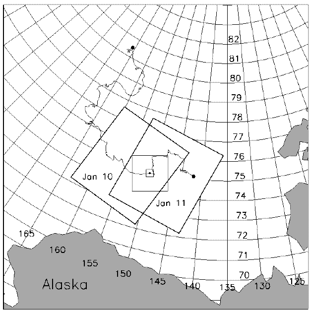
Figure 1. RADARSAT SAR image frames of January 10 and 11, 1998, illustrating the overlap that allows features in the first image to be tracked in the second image. The SHEBA drift track is also shown, with the position on January 11 marked by a small dot. Centered on the dot are two squares, 40 x 40 km and 200 x 200 km, showing the extent of the sub-images that have been extracted from the original SAR image.
 TOP
TOP
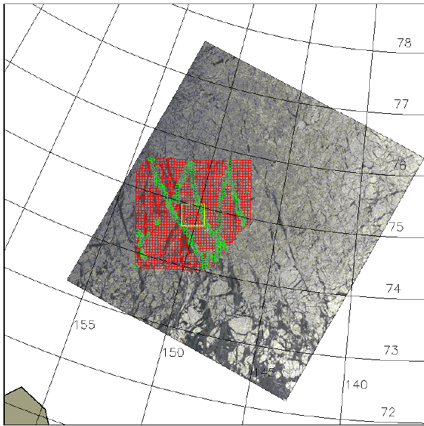
Figure 2. RADARSAT SAR image of January 11, 1998. The SHEBA station is at the center of the yellow box, which measures 40 x 40 km. The grid illustrates the relative motion of the sea ice since the previous day. Red cells have remained rigid; green cells have deformed more than 15% ( > 0.15). (Image copyright CSA 1998).
 TOP
TOP
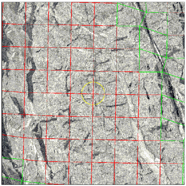
Figure 3. RADARSAT SAR sub-image of the 40 x 40 km region centered on the SHEBA station on January 11, 1998. This is a close-up of the yellow box in Figure 2. (Image copyright CSA 1998).
 TOP
TOP
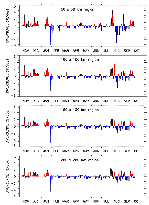
Figure 4. Time series of ice divergence in the vicinity of the SHEBA station, computed at four different spatial scales (averaging sizes) centered on the station.
 TOP
TOP
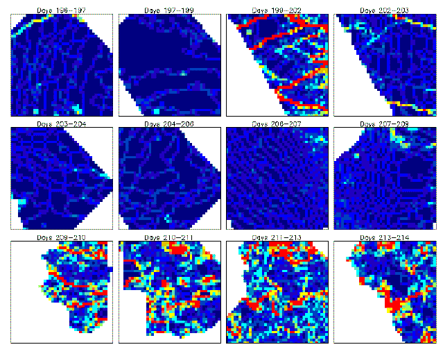
Figure 5. The spatial pattern of the magnitude of the ice strain,  , over 12 time intervals in the summer of 1998. Each panel is 200 x 200 km in size, with the SHEBA station at the center. Each 5-km cell is color-coded according to
  for that cell, from blue (
 = 0) through the spectrum to red (
 > 0.25). Day 196 is July 15 and Day 214 is August 2.
 TOP
TOP

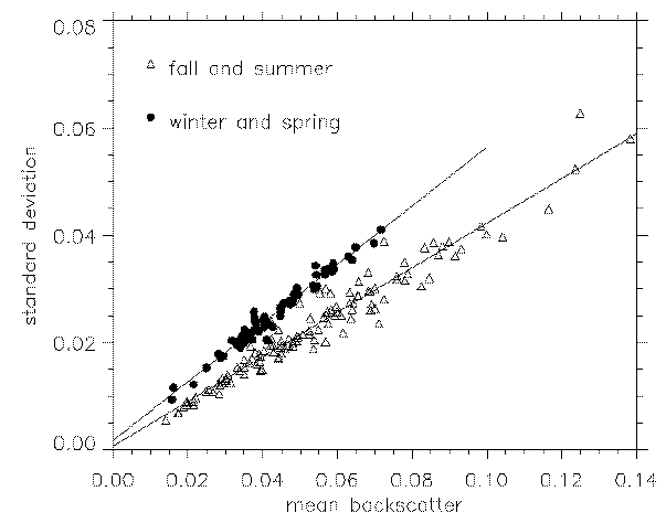
Figure 6. Standard deviation of backscatter vs. mean backscatter. Each symbol represents one 40 x 40 km sub-image. The slope of the linear relationship changes with season.
 TOP
TOP

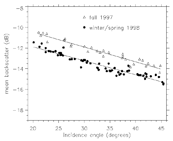
Figure 7. Mean backscatter vs. incidence angle. Each symbol represents one 40 x 40 km sub-image. The drop in backscatter from fall to winter/spring is due to the changing mix of ice types within the 40-km image frames.
 TOP
TOP

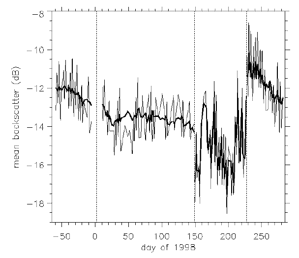
Figure 8. Mean backscatter vs. time for the 40 x 40 km sub-images. The high frequency variations are due to different incidence angles. The heavy line is an adjustment of the mean backscatter to a standard incidence angle of 32.5o. The mean winter backscatter is very stable compared to other seasons. Melt onset and freeze-up are marked by vertical dotted lines at May 29 (day 149) and August 15 (day 227).
 TOP
TOP

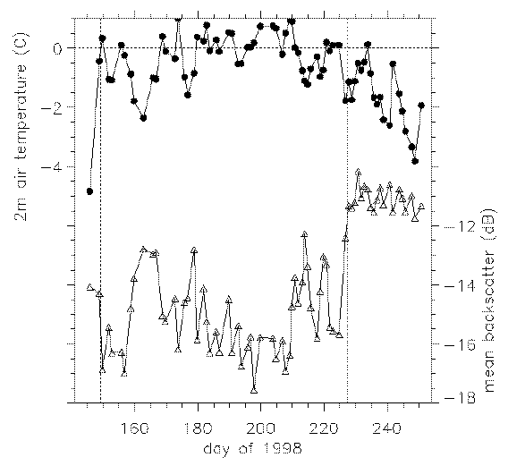
Figure 9. Daily 2-meter air temperature interpolated to the SAR image times (upper curve, left scale) and mean backscatter (adjusted to 32.5o incidence angle, lower curve, right scale) vs. time from May 25 (day 145) to September 7 (day 250). Melt onset and freeze-up are marked by vertical dotted lines at May 29 (day 149) and August 15 (day 227).
 TOP
TOP

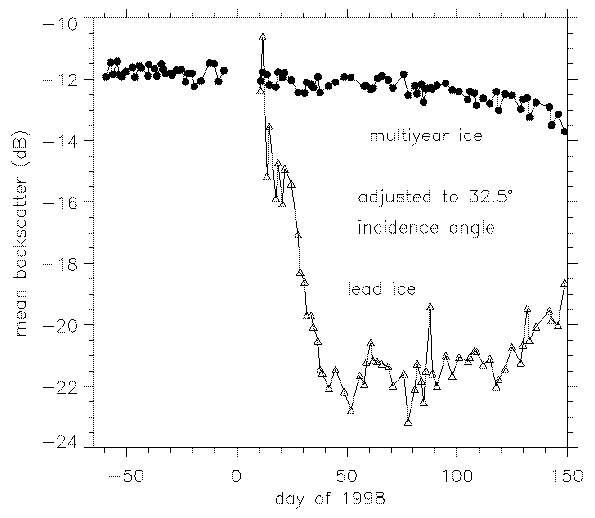
Figure 10. Mean backscatter (adjusted to 32.5o incidence angle) vs. time following a patch of multiyear ice (circles) and lead ice (triangles). The two ice types are generally well separated but lead ice can brighten briefly in the early stages of its formation, as on January 10-11.
 TOP
TOP

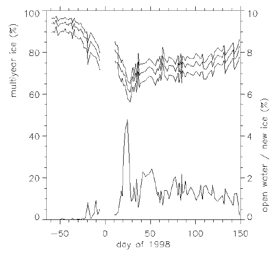
Figure 11. Multiyear ice concentration (upper curves, left scale) for three different thresholds, and open water / new ice concentration (lower curve, right scale). The SAR sub-images that follow the SHEBA station are not true Lagrangian elements - ice does advect in and out of the 40-km frames, so the concentration of multiyear ice is not constant.
 TOP
TOP
Back to "Introduction to the Data Sets"

 TOP
TOP
 > 0.15). (Image copyright CSA 1998).


 , over 12 time intervals in the summer of 1998. Each panel is 200 x 200 km in size, with the SHEBA station at the center. Each 5-km cell is color-coded according to
  for that cell, from blue (
 = 0) through the spectrum to red (
 > 0.25). Day 196 is July 15 and Day 214 is August 2.
