Sea Ice Motion
Introduction
The
RADARSAT Geophysical Processor System (RGPS),
by special arrangement with the SHEBA Project Office,
created 184 ice motion products from 184 sequential pairs
of RADARSAT SAR images of the SHEBA region. Please refer
back to the
Introduction to the Data Sets
for links to
Stern and Moritz [JGR, 2002]
which contains a more complete description.
Access to Data Products
Here is the site which contains the ice motion products,
a description of the file format, and
software for reading the products:
EOL Sea Ice Motion Webpage.
Cross Reference with SAR Images
In order to cross-reference the ice motion products with the RADARSAT
SAR images from which they were derived,
we created this
TABLE OF PRODUCT IDs.
The table contains 184 lines, one for each ice motion product.
Here is a list of the fields in the table:
- Line number
- RGPS product ID
- SAR image ID, first image
- Day of year, first image
- SAR image ID, second image
- Day of year, second image
Each RGPS product is associated with two SAR images acquired several
days apart. The products are listed in chronological order, so the
initial "day of year" values (305, 307, etc) refer to 1997. The
change to 1998 occurs at lines 33-34 when the "day of year" jumps from
356 to 10, 11, etc.
Graphical Products
The actual ice motion data files are just lists of numbers
of the form: x1, y1, x2, y2
where (x1,y1) are the initial coordinates
of a grid point, at the time of the first image, and
(x2,y2) are the final coordinates of the grid point,
at the time of the second image.
The points (x1,y1) lie on a regular
41 x 41 lattice with 5 km spacing. The SHEBA
station is located at the middle grid point.
However, not all 41 x 41 points are listed
in every ice motion product, because often the 200 x 200 km region
centered on the SHEBA station extends beyond the edge
of the satellite swath, making it impossible to track points there.
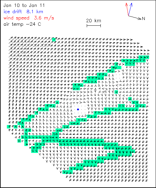
|
Each data product can be displayed as a vector field.
In the example to the right, the vectors are drawn relative to the drift
of the SHEBA station, which is the blue dot in the center.
The actual magnitude of the station drift is printed in blue
in the upper left (8.1 km here), and the actual
direction of drift is shown by the blue arrow in the upper right.
The black arrow and letter "N" indicate North.
The wind speed is printed in red (upper left) and the
wind direction is shown by the red arrow (upper right).
The ice motion vectors (black) all have the same size "heads".
The length of the shaft gives the displacement relative to the
SHEBA station. Relative displacements of less than 150 meters
are simply shown by a dot, no arrow. Relative displacements
of several hundred meters up to ~1 kilometer are so small
that the shaft is invisible, but the head indicates the direction.
The green squares are placed underneath those displacement vectors
that differ from the local mean displacement by more than
a certain threshold. Thus they
highlight the regions along which the ice motion changes abruptly.
(The local mean displacement is computed from a 3 x 3 set of
vectors, and the threshold is set at 0.5 km for both the u and v
displacement components).
|
 |
HOME